You are here: Home > Network List > CI - Caltech Regional Seismic Network Stations List
> Station MPP McPhearson Peak > Earthquake Result Viewer
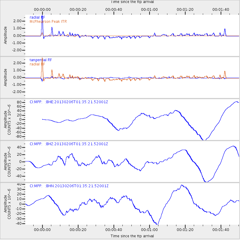
MPP McPhearson Peak - Earthquake Result Viewer
*The percent match for this event was below the threshold and hence no stack was calculated.
| Earthquake location: |
Santa Cruz Islands Region |
| Earthquake latitude/longitude: |
-11.2/164.9 |
| Earthquake time(UTC): |
2013/02/06 (037) 01:23:19 GMT |
| Earthquake Depth: |
10 km |
| Earthquake Magnitude: |
6.6 MB, 7.1 MW, 7.1 MW |
| Earthquake Catalog/Contributor: |
WHDF/NEIC |
|
| Network: |
CI Caltech Regional Seismic Network |
| Station: |
MPP McPhearson Peak |
| Lat/Lon: |
34.89 N/119.81 W |
| Elevation: |
1739 m |
|
| Distance: |
84.6 deg |
| Az: |
53.014 deg |
| Baz: |
252.452 deg |
| Ray Param: |
$rayparam |
*The percent match for this event was below the threshold and hence was not used in the summary stack. |
|
| Radial Match: |
73.18359 % |
| Radial Bump: |
400 |
| Transverse Match: |
62.35178 % |
| Transverse Bump: |
400 |
| SOD ConfigId: |
494114 |
| Insert Time: |
2013-05-01 05:01:11.511 +0000 |
| GWidth: |
2.5 |
| Max Bumps: |
400 |
| Tol: |
0.001 |
|
Signal To Noise
| Channel | StoN | STA | LTA |
| CI:MPP: :BHZ:20130206T01:35:21.52001Z | 3.3266912 | 1.0853937E-5 | 3.2626824E-6 |
| CI:MPP: :BHN:20130206T01:35:21.52001Z | 5.5349836 | 1.6693246E-5 | 3.0159522E-6 |
| CI:MPP: :BHE:20130206T01:35:21.52001Z | 3.3894174 | 1.9369681E-5 | 5.7147527E-6 |
| Arrivals |
| Ps | |
| PpPs | |
| PsPs/PpSs | |


