You are here: Home > Network List > CN - Canadian National Seismograph Network Stations List
> Station INK INUVIK, NT > Earthquake Result Viewer
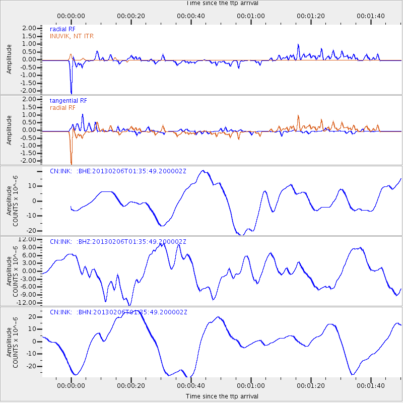
INK INUVIK, NT - Earthquake Result Viewer
*The percent match for this event was below the threshold and hence no stack was calculated.
| Earthquake location: |
Santa Cruz Islands Region |
| Earthquake latitude/longitude: |
-11.2/164.9 |
| Earthquake time(UTC): |
2013/02/06 (037) 01:23:19 GMT |
| Earthquake Depth: |
10 km |
| Earthquake Magnitude: |
6.6 MB, 7.1 MW, 7.1 MW |
| Earthquake Catalog/Contributor: |
WHDF/NEIC |
|
| Network: |
CN Canadian National Seismograph Network |
| Station: |
INK INUVIK, NT |
| Lat/Lon: |
68.31 N/133.53 W |
| Elevation: |
44 m |
|
| Distance: |
90.3 deg |
| Az: |
19.088 deg |
| Baz: |
239.668 deg |
| Ray Param: |
$rayparam |
*The percent match for this event was below the threshold and hence was not used in the summary stack. |
|
| Radial Match: |
87.04964 % |
| Radial Bump: |
346 |
| Transverse Match: |
81.01549 % |
| Transverse Bump: |
244 |
| SOD ConfigId: |
494114 |
| Insert Time: |
2013-05-01 05:02:25.962 +0000 |
| GWidth: |
2.5 |
| Max Bumps: |
400 |
| Tol: |
0.001 |
|
Signal To Noise
| Channel | StoN | STA | LTA |
| CN:INK: :BHZ:20130206T01:35:49.200002Z | 1.9736606 | 5.4298876E-6 | 2.7511758E-6 |
| CN:INK: :BHN:20130206T01:35:49.200002Z | 7.8745303 | 2.3788329E-5 | 3.0209203E-6 |
| CN:INK: :BHE:20130206T01:35:49.200002Z | 3.3684766 | 1.3468256E-5 | 3.9983224E-6 |
| Arrivals |
| Ps | |
| PpPs | |
| PsPs/PpSs | |


