You are here: Home > Network List > UW - Pacific Northwest Regional Seismic Network Stations List
> Station HOOD Mt Hood Meadows, OR CREST BB SMO > Earthquake Result Viewer
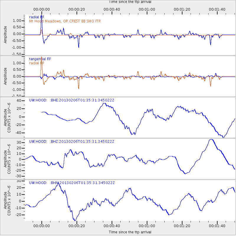
HOOD Mt Hood Meadows, OR CREST BB SMO - Earthquake Result Viewer
*The percent match for this event was below the threshold and hence no stack was calculated.
| Earthquake location: |
Santa Cruz Islands Region |
| Earthquake latitude/longitude: |
-11.2/164.9 |
| Earthquake time(UTC): |
2013/02/06 (037) 01:23:19 GMT |
| Earthquake Depth: |
10 km |
| Earthquake Magnitude: |
6.6 MB, 7.1 MW, 7.1 MW |
| Earthquake Catalog/Contributor: |
WHDF/NEIC |
|
| Network: |
UW Pacific Northwest Regional Seismic Network |
| Station: |
HOOD Mt Hood Meadows, OR CREST BB SMO |
| Lat/Lon: |
45.32 N/121.65 W |
| Elevation: |
1520 m |
|
| Distance: |
86.5 deg |
| Az: |
42.654 deg |
| Baz: |
250.459 deg |
| Ray Param: |
$rayparam |
*The percent match for this event was below the threshold and hence was not used in the summary stack. |
|
| Radial Match: |
56.30584 % |
| Radial Bump: |
348 |
| Transverse Match: |
49.90229 % |
| Transverse Bump: |
400 |
| SOD ConfigId: |
494114 |
| Insert Time: |
2013-05-01 05:09:12.126 +0000 |
| GWidth: |
2.5 |
| Max Bumps: |
400 |
| Tol: |
0.001 |
|
Signal To Noise
| Channel | StoN | STA | LTA |
| UW:HOOD: :BHZ:20130206T01:35:31.345022Z | 3.0845535 | 7.4245163E-6 | 2.4069989E-6 |
| UW:HOOD: :BHN:20130206T01:35:31.345022Z | 1.7359531 | 8.6417185E-6 | 4.978083E-6 |
| UW:HOOD: :BHE:20130206T01:35:31.345022Z | 2.3392622 | 1.781282E-5 | 7.614717E-6 |
| Arrivals |
| Ps | |
| PpPs | |
| PsPs/PpSs | |


