You are here: Home > Network List > UW - Pacific Northwest Regional Seismic Network Stations List
> Station WOLL Wollman Farm, Schrag, WA, USA > Earthquake Result Viewer
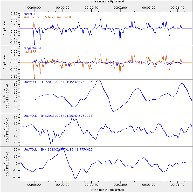
WOLL Wollman Farm, Schrag, WA, USA - Earthquake Result Viewer
*The percent match for this event was below the threshold and hence no stack was calculated.
| Earthquake location: |
Santa Cruz Islands Region |
| Earthquake latitude/longitude: |
-11.2/164.9 |
| Earthquake time(UTC): |
2013/02/06 (037) 01:23:19 GMT |
| Earthquake Depth: |
10 km |
| Earthquake Magnitude: |
6.6 MB, 7.1 MW, 7.1 MW |
| Earthquake Catalog/Contributor: |
WHDF/NEIC |
|
| Network: |
UW Pacific Northwest Regional Seismic Network |
| Station: |
WOLL Wollman Farm, Schrag, WA, USA |
| Lat/Lon: |
47.06 N/118.92 W |
| Elevation: |
385 m |
|
| Distance: |
88.9 deg |
| Az: |
41.613 deg |
| Baz: |
252.383 deg |
| Ray Param: |
$rayparam |
*The percent match for this event was below the threshold and hence was not used in the summary stack. |
|
| Radial Match: |
58.075787 % |
| Radial Bump: |
251 |
| Transverse Match: |
63.2505 % |
| Transverse Bump: |
253 |
| SOD ConfigId: |
494114 |
| Insert Time: |
2013-05-01 05:09:20.774 +0000 |
| GWidth: |
2.5 |
| Max Bumps: |
400 |
| Tol: |
0.001 |
|
Signal To Noise
| Channel | StoN | STA | LTA |
| UW:WOLL: :BHZ:20130206T01:35:42.575002Z | 1.5948756 | 5.333708E-6 | 3.3442784E-6 |
| UW:WOLL: :BHN:20130206T01:35:42.575002Z | 3.2141886 | 8.493092E-6 | 2.642375E-6 |
| UW:WOLL: :BHE:20130206T01:35:42.575002Z | 2.2792401 | 1.3395684E-5 | 5.8772584E-6 |
| Arrivals |
| Ps | |
| PpPs | |
| PsPs/PpSs | |


