You are here: Home > Network List > TA - USArray Transportable Network (new EarthScope stations) Stations List
> Station G03D McMinnville, OR, USA > Earthquake Result Viewer
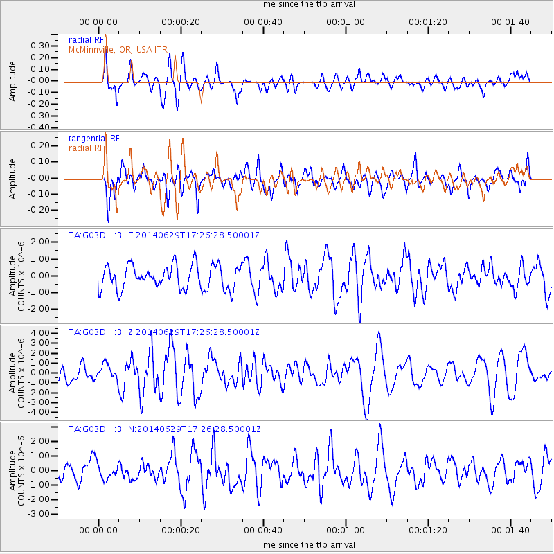
G03D McMinnville, OR, USA - Earthquake Result Viewer
*The percent match for this event was below the threshold and hence no stack was calculated.
| Earthquake location: |
Tonga Islands |
| Earthquake latitude/longitude: |
-15.0/-175.6 |
| Earthquake time(UTC): |
2014/06/29 (180) 17:15:08 GMT |
| Earthquake Depth: |
10 km |
| Earthquake Magnitude: |
6.7 MWW, 6.7 MWC, 6.8 MI |
| Earthquake Catalog/Contributor: |
NEIC PDE/NEIC COMCAT |
|
| Network: |
TA USArray Transportable Network (new EarthScope stations) |
| Station: |
G03D McMinnville, OR, USA |
| Lat/Lon: |
45.21 N/123.26 W |
| Elevation: |
222 m |
|
| Distance: |
76.4 deg |
| Az: |
35.131 deg |
| Baz: |
231.863 deg |
| Ray Param: |
$rayparam |
*The percent match for this event was below the threshold and hence was not used in the summary stack. |
|
| Radial Match: |
73.72092 % |
| Radial Bump: |
400 |
| Transverse Match: |
60.625534 % |
| Transverse Bump: |
400 |
| SOD ConfigId: |
3390531 |
| Insert Time: |
2019-04-12 14:40:56.177 +0000 |
| GWidth: |
2.5 |
| Max Bumps: |
400 |
| Tol: |
0.001 |
|
Signal To Noise
| Channel | StoN | STA | LTA |
| TA:G03D: :BHZ:20140629T17:26:28.50001Z | 1.3845146 | 8.2044346E-7 | 5.9258565E-7 |
| TA:G03D: :BHN:20140629T17:26:28.50001Z | 0.7992259 | 5.543165E-7 | 6.9356673E-7 |
| TA:G03D: :BHE:20140629T17:26:28.50001Z | 1.2785487 | 8.274404E-7 | 6.471716E-7 |
| Arrivals |
| Ps | |
| PpPs | |
| PsPs/PpSs | |


