You are here: Home > Network List > CN - Canadian National Seismograph Network Stations List
> Station INK INUVIK, NT > Earthquake Result Viewer
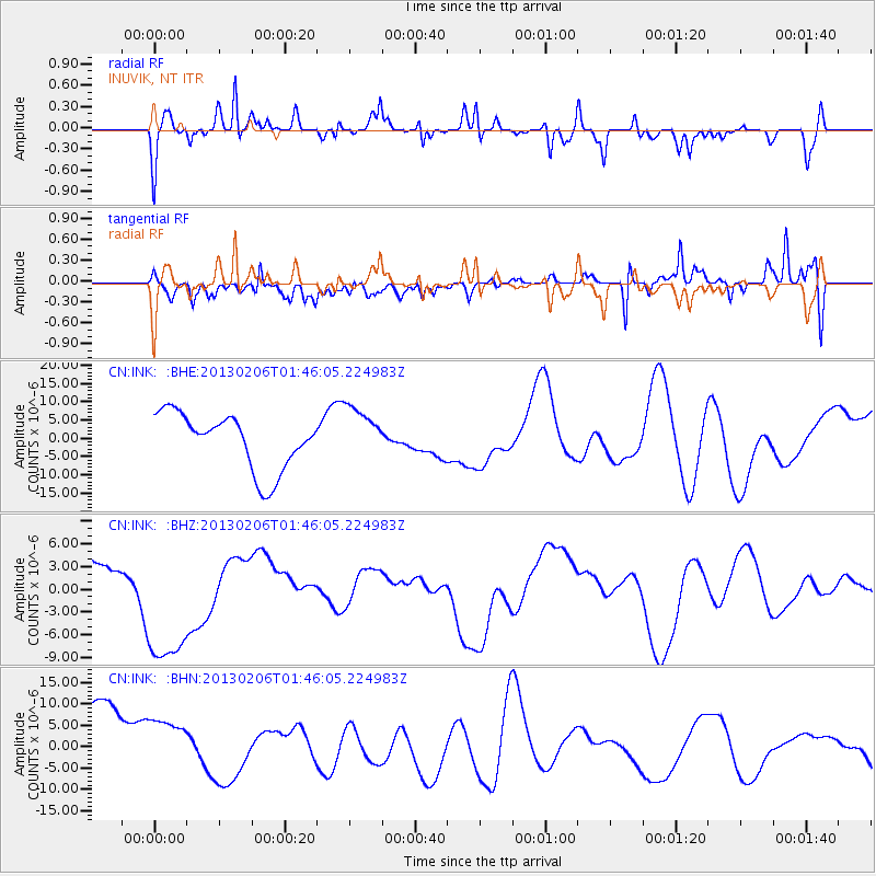
INK INUVIK, NT - Earthquake Result Viewer
*The percent match for this event was below the threshold and hence no stack was calculated.
| Earthquake location: |
Santa Cruz Islands |
| Earthquake latitude/longitude: |
-11.0/165.2 |
| Earthquake time(UTC): |
2013/02/06 (037) 01:33:37 GMT |
| Earthquake Depth: |
10 km |
| Earthquake Magnitude: |
5.6 MB |
| Earthquake Catalog/Contributor: |
WHDF/NEIC |
|
| Network: |
CN Canadian National Seismograph Network |
| Station: |
INK INUVIK, NT |
| Lat/Lon: |
68.31 N/133.53 W |
| Elevation: |
44 m |
|
| Distance: |
90.0 deg |
| Az: |
19.027 deg |
| Baz: |
239.432 deg |
| Ray Param: |
$rayparam |
*The percent match for this event was below the threshold and hence was not used in the summary stack. |
|
| Radial Match: |
47.37287 % |
| Radial Bump: |
358 |
| Transverse Match: |
56.060616 % |
| Transverse Bump: |
400 |
| SOD ConfigId: |
494114 |
| Insert Time: |
2013-05-01 05:28:09.014 +0000 |
| GWidth: |
2.5 |
| Max Bumps: |
400 |
| Tol: |
0.001 |
|
Signal To Noise
| Channel | StoN | STA | LTA |
| CN:INK: :BHZ:20130206T01:46:05.224983Z | 2.9627597 | 9.544514E-6 | 3.2214944E-6 |
| CN:INK: :BHN:20130206T01:46:05.224983Z | 0.6391609 | 7.850447E-6 | 1.22824285E-5 |
| CN:INK: :BHE:20130206T01:46:05.224983Z | 0.96966344 | 7.3830342E-6 | 7.6140172E-6 |
| Arrivals |
| Ps | |
| PpPs | |
| PsPs/PpSs | |


