You are here: Home > Network List > IW - Intermountain West Stations List
> Station PLID Pearl Lake, Idaho, USA > Earthquake Result Viewer
PLID Pearl Lake, Idaho, USA - Earthquake Result Viewer
*The percent match for this event was below the threshold and hence no stack was calculated.
| Earthquake location: |
Santa Cruz Islands |
| Earthquake latitude/longitude: |
-11.0/165.2 |
| Earthquake time(UTC): |
2013/02/06 (037) 01:33:37 GMT |
| Earthquake Depth: |
10 km |
| Earthquake Magnitude: |
5.6 MB |
| Earthquake Catalog/Contributor: |
WHDF/NEIC |
|
| Network: |
IW Intermountain West |
| Station: |
PLID Pearl Lake, Idaho, USA |
| Lat/Lon: |
45.09 N/116.00 W |
| Elevation: |
2164 m |
|
| Distance: |
89.9 deg |
| Az: |
44.018 deg |
| Baz: |
254.412 deg |
| Ray Param: |
$rayparam |
*The percent match for this event was below the threshold and hence was not used in the summary stack. |
|
| Radial Match: |
36.005756 % |
| Radial Bump: |
400 |
| Transverse Match: |
56.662655 % |
| Transverse Bump: |
390 |
| SOD ConfigId: |
494114 |
| Insert Time: |
2013-05-01 05:30:47.421 +0000 |
| GWidth: |
2.5 |
| Max Bumps: |
400 |
| Tol: |
0.001 |
|
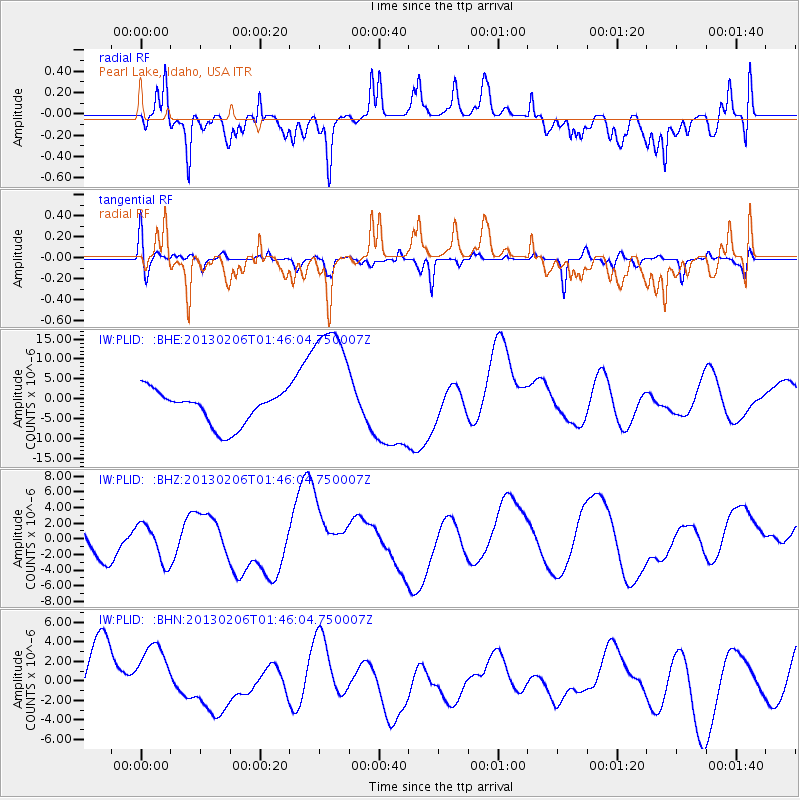
Signal To Noise
| Channel | StoN | STA | LTA |
| IW:PLID: :BHZ:20130206T01:46:04.750007Z | 1.441807 | 2.4280785E-6 | 1.6840523E-6 |
| IW:PLID: :BHN:20130206T01:46:04.750007Z | 1.1950318 | 3.4512211E-6 | 2.8879742E-6 |
| IW:PLID: :BHE:20130206T01:46:04.750007Z | 3.983827 | 1.7069866E-5 | 4.2847905E-6 |
| Arrivals |
| Ps | |
| PpPs | |
| PsPs/PpSs | |


