You are here: Home > Network List > CB - China National Seismic Network Stations List
> Station TIA Taian,Shandong Province > Earthquake Result Viewer
TIA Taian,Shandong Province - Earthquake Result Viewer
| Earthquake location: |
Santa Cruz Islands |
| Earthquake latitude/longitude: |
-11.8/165.3 |
| Earthquake time(UTC): |
2013/02/06 (037) 01:36:06 GMT |
| Earthquake Depth: |
10 km |
| Earthquake Magnitude: |
5.5 MB |
| Earthquake Catalog/Contributor: |
WHDF/NEIC |
|
| Network: |
CB China National Seismic Network |
| Station: |
TIA Taian,Shandong Province |
| Lat/Lon: |
36.21 N/117.12 E |
| Elevation: |
267 m |
|
| Distance: |
65.9 deg |
| Az: |
318.68 deg |
| Baz: |
126.932 deg |
| Ray Param: |
0.057972703 |
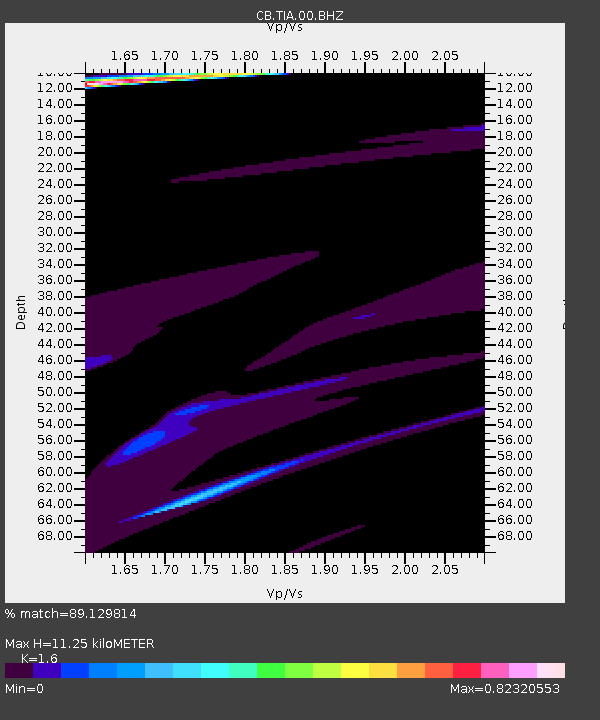
| Estimated Moho Depth: |
11.25 km |
| Estimated Crust Vp/Vs: |
1.60 |
| Assumed Crust Vp: |
6.363 km/s |
| Estimated Crust Vs: |
3.977 km/s |
| Estimated Crust Poisson's Ratio: |
0.18 |
|
| Radial Match: |
89.129814 % |
| Radial Bump: |
400 |
| Transverse Match: |
49.944557 % |
| Transverse Bump: |
400 |
| SOD ConfigId: |
494114 |
| Insert Time: |
2013-05-01 05:35:05.917 +0000 |
| GWidth: |
2.5 |
| Max Bumps: |
400 |
| Tol: |
0.001 |
|

Signal To Noise
| Channel | StoN | STA | LTA |
| CB:TIA:00:BHZ:20130206T01:46:21.189973Z | 3.9558003 | 1.7766106E-5 | 4.4911535E-6 |
| CB:TIA:00:BHN:20130206T01:46:21.189973Z | 2.6269379 | 1.3554414E-5 | 5.1597776E-6 |
| CB:TIA:00:BHE:20130206T01:46:21.189973Z | 2.8391104 | 4.643735E-6 | 1.6356303E-6 |
| Arrivals |
| Ps | 1.1 SECOND |
| PpPs | 4.4 SECOND |
| PsPs/PpSs | 5.5 SECOND |


