You are here: Home > Network List > TA - USArray Transportable Network (new EarthScope stations) Stations List
> Station R11A Troy Canyon, Currant, NV, USA > Earthquake Result Viewer
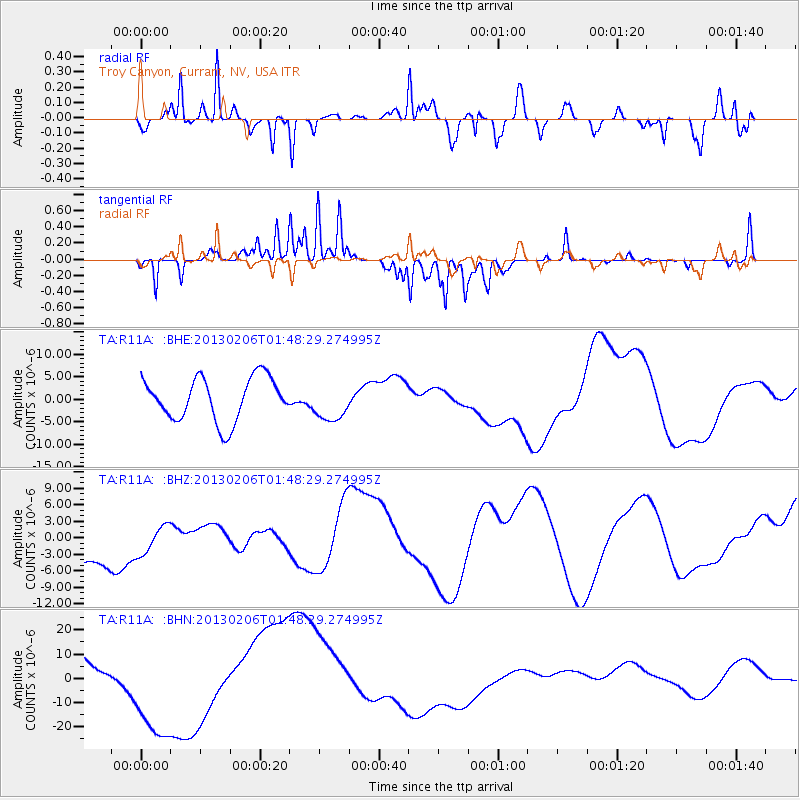
R11A Troy Canyon, Currant, NV, USA - Earthquake Result Viewer
*The percent match for this event was below the threshold and hence no stack was calculated.
| Earthquake location: |
Santa Cruz Islands |
| Earthquake latitude/longitude: |
-11.8/165.3 |
| Earthquake time(UTC): |
2013/02/06 (037) 01:36:06 GMT |
| Earthquake Depth: |
10 km |
| Earthquake Magnitude: |
5.5 MB |
| Earthquake Catalog/Contributor: |
WHDF/NEIC |
|
| Network: |
TA USArray Transportable Network (new EarthScope stations) |
| Station: |
R11A Troy Canyon, Currant, NV, USA |
| Lat/Lon: |
38.35 N/115.59 W |
| Elevation: |
1756 m |
|
| Distance: |
88.9 deg |
| Az: |
50.558 deg |
| Baz: |
254.086 deg |
| Ray Param: |
$rayparam |
*The percent match for this event was below the threshold and hence was not used in the summary stack. |
|
| Radial Match: |
72.77713 % |
| Radial Bump: |
343 |
| Transverse Match: |
55.216957 % |
| Transverse Bump: |
139 |
| SOD ConfigId: |
494114 |
| Insert Time: |
2013-05-01 05:39:53.120 +0000 |
| GWidth: |
2.5 |
| Max Bumps: |
400 |
| Tol: |
0.001 |
|
Signal To Noise
| Channel | StoN | STA | LTA |
| TA:R11A: :BHZ:20130206T01:48:29.274995Z | 0.6795313 | 2.936668E-6 | 4.3216082E-6 |
| TA:R11A: :BHN:20130206T01:48:29.274995Z | 6.4906363 | 2.3930412E-5 | 3.6869133E-6 |
| TA:R11A: :BHE:20130206T01:48:29.274995Z | 0.8645149 | 4.1351022E-6 | 4.7831472E-6 |
| Arrivals |
| Ps | |
| PpPs | |
| PsPs/PpSs | |


