You are here: Home > Network List > TA - USArray Transportable Network (new EarthScope stations) Stations List
> Station A04D Lummi Island, WA, USA > Earthquake Result Viewer
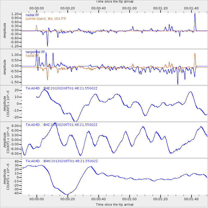
A04D Lummi Island, WA, USA - Earthquake Result Viewer
*The percent match for this event was below the threshold and hence no stack was calculated.
| Earthquake location: |
Santa Cruz Islands |
| Earthquake latitude/longitude: |
-11.8/165.3 |
| Earthquake time(UTC): |
2013/02/06 (037) 01:36:06 GMT |
| Earthquake Depth: |
10 km |
| Earthquake Magnitude: |
5.5 MB |
| Earthquake Catalog/Contributor: |
WHDF/NEIC |
|
| Network: |
TA USArray Transportable Network (new EarthScope stations) |
| Station: |
A04D Lummi Island, WA, USA |
| Lat/Lon: |
48.72 N/122.71 W |
| Elevation: |
13 m |
|
| Distance: |
87.2 deg |
| Az: |
39.089 deg |
| Baz: |
248.785 deg |
| Ray Param: |
$rayparam |
*The percent match for this event was below the threshold and hence was not used in the summary stack. |
|
| Radial Match: |
74.83519 % |
| Radial Bump: |
400 |
| Transverse Match: |
49.304325 % |
| Transverse Bump: |
400 |
| SOD ConfigId: |
494114 |
| Insert Time: |
2013-05-01 05:40:12.555 +0000 |
| GWidth: |
2.5 |
| Max Bumps: |
400 |
| Tol: |
0.001 |
|
Signal To Noise
| Channel | StoN | STA | LTA |
| TA:A04D: :BHZ:20130206T01:48:21.55002Z | 0.59022486 | 3.2244448E-6 | 5.4630787E-6 |
| TA:A04D: :BHN:20130206T01:48:21.55002Z | 1.591559 | 3.6865058E-5 | 2.3162858E-5 |
| TA:A04D: :BHE:20130206T01:48:21.55002Z | 0.32517338 | 4.5445586E-6 | 1.3975801E-5 |
| Arrivals |
| Ps | |
| PpPs | |
| PsPs/PpSs | |


