You are here: Home > Network List > TA - USArray Transportable Network (new EarthScope stations) Stations List
> Station H17A Grant Village (NPS), Yellowstone Nt. Park, WY, USA > Earthquake Result Viewer
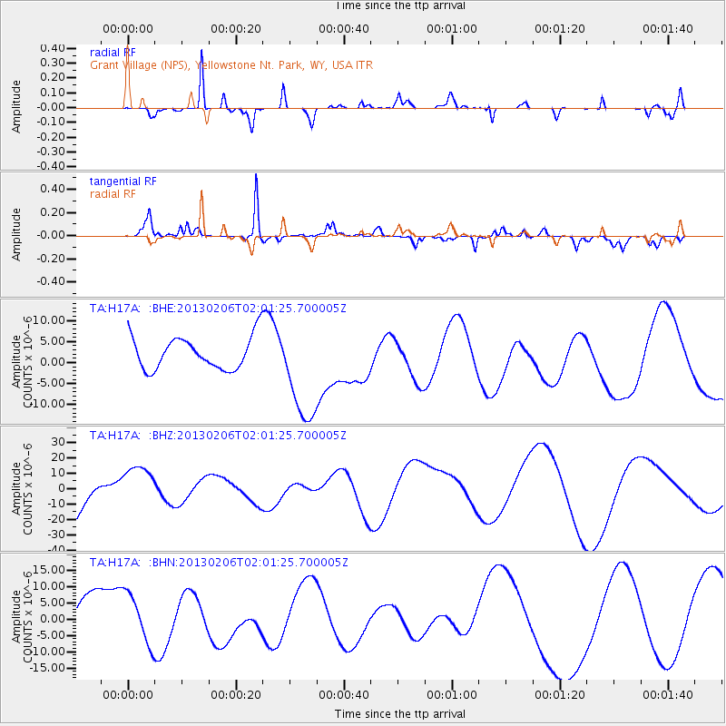
H17A Grant Village (NPS), Yellowstone Nt. Park, WY, USA - Earthquake Result Viewer
*The percent match for this event was below the threshold and hence no stack was calculated.
| Earthquake location: |
Santa Cruz Islands |
| Earthquake latitude/longitude: |
-11.6/166.0 |
| Earthquake time(UTC): |
2013/02/06 (037) 01:48:42 GMT |
| Earthquake Depth: |
10 km |
| Earthquake Magnitude: |
5.5 MB |
| Earthquake Catalog/Contributor: |
WHDF/NEIC |
|
| Network: |
TA USArray Transportable Network (new EarthScope stations) |
| Station: |
H17A Grant Village (NPS), Yellowstone Nt. Park, WY, USA |
| Lat/Lon: |
44.40 N/110.58 W |
| Elevation: |
2400 m |
|
| Distance: |
93.4 deg |
| Az: |
45.511 deg |
| Baz: |
257.148 deg |
| Ray Param: |
$rayparam |
*The percent match for this event was below the threshold and hence was not used in the summary stack. |
|
| Radial Match: |
76.98595 % |
| Radial Bump: |
247 |
| Transverse Match: |
78.01143 % |
| Transverse Bump: |
246 |
| SOD ConfigId: |
494114 |
| Insert Time: |
2013-05-01 05:49:28.501 +0000 |
| GWidth: |
2.5 |
| Max Bumps: |
400 |
| Tol: |
0.001 |
|
Signal To Noise
| Channel | StoN | STA | LTA |
| TA:H17A: :BHZ:20130206T02:01:25.700005Z | 0.952751 | 1.3961982E-5 | 1.4654388E-5 |
| TA:H17A: :BHN:20130206T02:01:25.700005Z | 1.2239116 | 7.703854E-6 | 6.2944528E-6 |
| TA:H17A: :BHE:20130206T02:01:25.700005Z | 3.2369967 | 1.2416061E-5 | 3.835673E-6 |
| Arrivals |
| Ps | |
| PpPs | |
| PsPs/PpSs | |


