You are here: Home > Network List > TA - USArray Transportable Network (new EarthScope stations) Stations List
> Station H17A Grant Village (NPS), Yellowstone Nt. Park, WY, USA > Earthquake Result Viewer
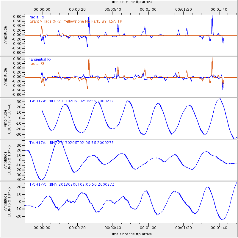
H17A Grant Village (NPS), Yellowstone Nt. Park, WY, USA - Earthquake Result Viewer
*The percent match for this event was below the threshold and hence no stack was calculated.
| Earthquake location: |
Santa Cruz Islands |
| Earthquake latitude/longitude: |
-10.5/165.6 |
| Earthquake time(UTC): |
2013/02/06 (037) 01:54:14 GMT |
| Earthquake Depth: |
8.8 km |
| Earthquake Magnitude: |
6.5 MB, 7.0 MW, 7.0 MW |
| Earthquake Catalog/Contributor: |
WHDF/NEIC |
|
| Network: |
TA USArray Transportable Network (new EarthScope stations) |
| Station: |
H17A Grant Village (NPS), Yellowstone Nt. Park, WY, USA |
| Lat/Lon: |
44.40 N/110.58 W |
| Elevation: |
2400 m |
|
| Distance: |
92.9 deg |
| Az: |
45.532 deg |
| Baz: |
258.248 deg |
| Ray Param: |
$rayparam |
*The percent match for this event was below the threshold and hence was not used in the summary stack. |
|
| Radial Match: |
92.92054 % |
| Radial Bump: |
197 |
| Transverse Match: |
84.74138 % |
| Transverse Bump: |
334 |
| SOD ConfigId: |
494114 |
| Insert Time: |
2013-05-01 05:57:02.859 +0000 |
| GWidth: |
2.5 |
| Max Bumps: |
400 |
| Tol: |
0.001 |
|
Signal To Noise
| Channel | StoN | STA | LTA |
| TA:H17A: :BHZ:20130206T02:06:56.200027Z | 1.8929347 | 3.437318E-5 | 1.8158673E-5 |
| TA:H17A: :BHN:20130206T02:06:56.200027Z | 1.4059426 | 5.5742203E-6 | 3.9647566E-6 |
| TA:H17A: :BHE:20130206T02:06:56.200027Z | 1.6259407 | 2.817049E-5 | 1.7325658E-5 |
| Arrivals |
| Ps | |
| PpPs | |
| PsPs/PpSs | |


