You are here: Home > Network List > YT07 - POLENET Stations List
> Station MPAT MPAT > Earthquake Result Viewer
MPAT MPAT - Earthquake Result Viewer
| Earthquake location: |
Tonga Islands |
| Earthquake latitude/longitude: |
-15.0/-175.6 |
| Earthquake time(UTC): |
2014/06/29 (180) 17:15:08 GMT |
| Earthquake Depth: |
10 km |
| Earthquake Magnitude: |
6.7 MWW, 6.7 MWC, 6.8 MI |
| Earthquake Catalog/Contributor: |
NEIC PDE/NEIC COMCAT |
|
| Network: |
YT POLENET |
| Station: |
MPAT MPAT |
| Lat/Lon: |
78.03 S/155.02 W |
| Elevation: |
540 m |
|
| Distance: |
63.8 deg |
| Az: |
175.318 deg |
| Baz: |
337.802 deg |
| Ray Param: |
0.05932361 |
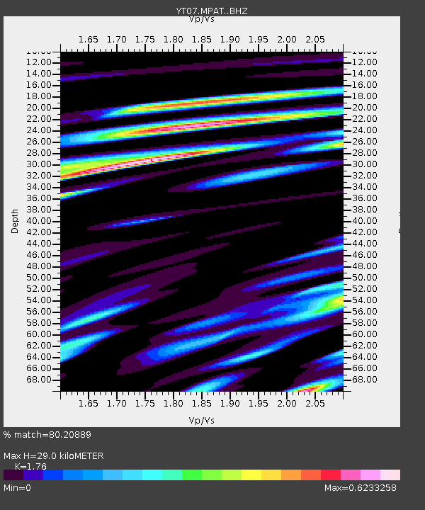
| Estimated Moho Depth: |
29.0 km |
| Estimated Crust Vp/Vs: |
1.76 |
| Assumed Crust Vp: |
6.43 km/s |
| Estimated Crust Vs: |
3.653 km/s |
| Estimated Crust Poisson's Ratio: |
0.26 |
|
| Radial Match: |
80.20889 % |
| Radial Bump: |
400 |
| Transverse Match: |
83.54837 % |
| Transverse Bump: |
400 |
| SOD ConfigId: |
3390531 |
| Insert Time: |
2019-04-12 14:42:50.945 +0000 |
| GWidth: |
2.5 |
| Max Bumps: |
400 |
| Tol: |
0.001 |
|

Signal To Noise
| Channel | StoN | STA | LTA |
| YT:MPAT: :BHZ:20140629T17:25:09.825022Z | 1.7627974 | 1.1707341E-6 | 6.6413423E-7 |
| YT:MPAT: :BHN:20140629T17:25:09.825022Z | 1.2424624 | 3.1300516E-7 | 2.5192327E-7 |
| YT:MPAT: :BHE:20140629T17:25:09.825022Z | 1.3603033 | 5.2954545E-7 | 3.8928482E-7 |
| Arrivals |
| Ps | 3.6 SECOND |
| PpPs | 12 SECOND |
| PsPs/PpSs | 15 SECOND |


