You are here: Home > Network List > TA - USArray Transportable Network (new EarthScope stations) Stations List
> Station HDA Harding Lake, AK, USA > Earthquake Result Viewer
HDA Harding Lake, AK, USA - Earthquake Result Viewer
| Earthquake location: |
Santa Cruz Islands |
| Earthquake latitude/longitude: |
-11.1/165.4 |
| Earthquake time(UTC): |
2013/02/06 (037) 01:59:33 GMT |
| Earthquake Depth: |
10 km |
| Earthquake Magnitude: |
5.5 MB |
| Earthquake Catalog/Contributor: |
WHDF/NEIC |
|
| Network: |
TA USArray Transportable Network (new EarthScope stations) |
| Station: |
HDA Harding Lake, AK, USA |
| Lat/Lon: |
64.41 N/146.95 W |
| Elevation: |
437 m |
|
| Distance: |
83.4 deg |
| Az: |
18.856 deg |
| Baz: |
226.918 deg |
| Ray Param: |
0.04620098 |
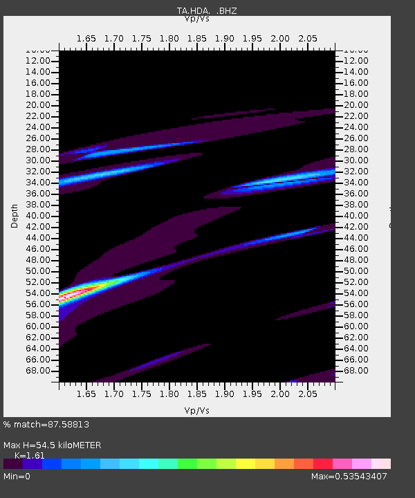
| Estimated Moho Depth: |
54.5 km |
| Estimated Crust Vp/Vs: |
1.61 |
| Assumed Crust Vp: |
6.566 km/s |
| Estimated Crust Vs: |
4.078 km/s |
| Estimated Crust Poisson's Ratio: |
0.19 |
|
| Radial Match: |
87.58813 % |
| Radial Bump: |
400 |
| Transverse Match: |
89.11819 % |
| Transverse Bump: |
296 |
| SOD ConfigId: |
494114 |
| Insert Time: |
2013-05-01 06:11:17.996 +0000 |
| GWidth: |
2.5 |
| Max Bumps: |
400 |
| Tol: |
0.001 |
|

Signal To Noise
| Channel | StoN | STA | LTA |
| TA:HDA: :BHZ:20130206T02:11:29.944995Z | 2.2647035 | 2.0817557E-5 | 9.1921775E-6 |
| TA:HDA: :BHN:20130206T02:11:29.944995Z | 1.491734 | 1.761845E-5 | 1.1810718E-5 |
| TA:HDA: :BHE:20130206T02:11:29.944995Z | 1.3501208 | 1.5491993E-5 | 1.14745235E-5 |
| Arrivals |
| Ps | 5.2 SECOND |
| PpPs | 21 SECOND |
| PsPs/PpSs | 26 SECOND |


