You are here: Home > Network List > TA - USArray Transportable Network (new EarthScope stations) Stations List
> Station 121A Cookes Peak, Deming, NM, USA > Earthquake Result Viewer
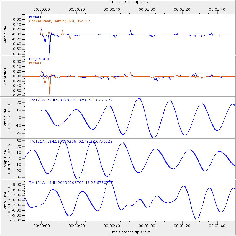
121A Cookes Peak, Deming, NM, USA - Earthquake Result Viewer
*The percent match for this event was below the threshold and hence no stack was calculated.
| Earthquake location: |
Santa Cruz Islands |
| Earthquake latitude/longitude: |
-10.8/165.1 |
| Earthquake time(UTC): |
2013/02/06 (037) 02:30:44 GMT |
| Earthquake Depth: |
10 km |
| Earthquake Magnitude: |
5.6 MB |
| Earthquake Catalog/Contributor: |
WHDF/NEIC |
|
| Network: |
TA USArray Transportable Network (new EarthScope stations) |
| Station: |
121A Cookes Peak, Deming, NM, USA |
| Lat/Lon: |
32.53 N/107.79 W |
| Elevation: |
1652 m |
|
| Distance: |
93.3 deg |
| Az: |
57.68 deg |
| Baz: |
259.396 deg |
| Ray Param: |
$rayparam |
*The percent match for this event was below the threshold and hence was not used in the summary stack. |
|
| Radial Match: |
95.309616 % |
| Radial Bump: |
256 |
| Transverse Match: |
78.41416 % |
| Transverse Bump: |
400 |
| SOD ConfigId: |
494114 |
| Insert Time: |
2013-05-01 06:17:57.746 +0000 |
| GWidth: |
2.5 |
| Max Bumps: |
400 |
| Tol: |
0.001 |
|
Signal To Noise
| Channel | StoN | STA | LTA |
| TA:121A: :BHZ:20130206T02:43:27.675022Z | 2.237203 | 1.9489591E-5 | 8.711589E-6 |
| TA:121A: :BHN:20130206T02:43:27.675022Z | 0.69364053 | 2.6867685E-6 | 3.8734306E-6 |
| TA:121A: :BHE:20130206T02:43:27.675022Z | 1.4663144 | 1.0754104E-5 | 7.3341052E-6 |
| Arrivals |
| Ps | |
| PpPs | |
| PsPs/PpSs | |


