You are here: Home > Network List > TA - USArray Transportable Network (new EarthScope stations) Stations List
> Station G03D McMinnville, OR, USA > Earthquake Result Viewer
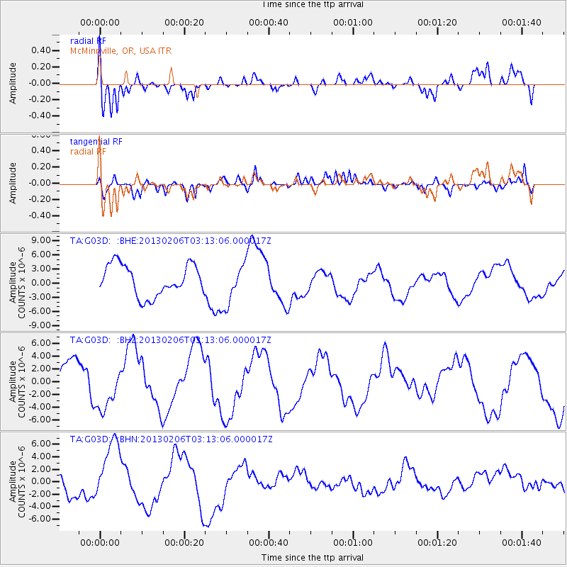
G03D McMinnville, OR, USA - Earthquake Result Viewer
*The percent match for this event was below the threshold and hence no stack was calculated.
| Earthquake location: |
Santa Cruz Islands |
| Earthquake latitude/longitude: |
-11.1/165.1 |
| Earthquake time(UTC): |
2013/02/06 (037) 03:01:01 GMT |
| Earthquake Depth: |
12 km |
| Earthquake Magnitude: |
5.6 MB |
| Earthquake Catalog/Contributor: |
WHDF/NEIC |
|
| Network: |
TA USArray Transportable Network (new EarthScope stations) |
| Station: |
G03D McMinnville, OR, USA |
| Lat/Lon: |
45.21 N/123.26 W |
| Elevation: |
222 m |
|
| Distance: |
85.2 deg |
| Az: |
42.323 deg |
| Baz: |
249.244 deg |
| Ray Param: |
$rayparam |
*The percent match for this event was below the threshold and hence was not used in the summary stack. |
|
| Radial Match: |
76.577354 % |
| Radial Bump: |
400 |
| Transverse Match: |
41.060795 % |
| Transverse Bump: |
400 |
| SOD ConfigId: |
494114 |
| Insert Time: |
2013-05-01 06:32:27.095 +0000 |
| GWidth: |
2.5 |
| Max Bumps: |
400 |
| Tol: |
0.001 |
|
Signal To Noise
| Channel | StoN | STA | LTA |
| TA:G03D: :BHZ:20130206T03:13:06.000017Z | 0.975373 | 3.6115516E-6 | 3.702739E-6 |
| TA:G03D: :BHN:20130206T03:13:06.000017Z | 2.9100008 | 5.532955E-6 | 1.9013586E-6 |
| TA:G03D: :BHE:20130206T03:13:06.000017Z | 1.3166566 | 4.32448E-6 | 3.2844403E-6 |
| Arrivals |
| Ps | |
| PpPs | |
| PsPs/PpSs | |


