You are here: Home > Network List > UW - Pacific Northwest Regional Seismic Network Stations List
> Station HOOD Mt Hood Meadows, OR CREST BB SMO > Earthquake Result Viewer
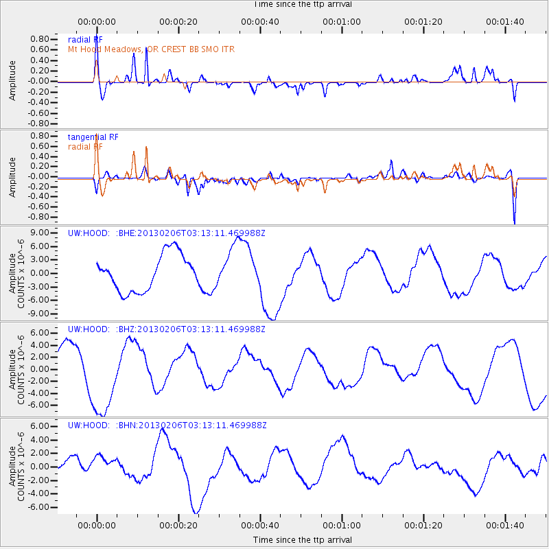
HOOD Mt Hood Meadows, OR CREST BB SMO - Earthquake Result Viewer
*The percent match for this event was below the threshold and hence no stack was calculated.
| Earthquake location: |
Santa Cruz Islands |
| Earthquake latitude/longitude: |
-11.1/165.1 |
| Earthquake time(UTC): |
2013/02/06 (037) 03:01:01 GMT |
| Earthquake Depth: |
12 km |
| Earthquake Magnitude: |
5.6 MB |
| Earthquake Catalog/Contributor: |
WHDF/NEIC |
|
| Network: |
UW Pacific Northwest Regional Seismic Network |
| Station: |
HOOD Mt Hood Meadows, OR CREST BB SMO |
| Lat/Lon: |
45.32 N/121.65 W |
| Elevation: |
1520 m |
|
| Distance: |
86.3 deg |
| Az: |
42.613 deg |
| Baz: |
250.406 deg |
| Ray Param: |
$rayparam |
*The percent match for this event was below the threshold and hence was not used in the summary stack. |
|
| Radial Match: |
76.901276 % |
| Radial Bump: |
400 |
| Transverse Match: |
69.48778 % |
| Transverse Bump: |
400 |
| SOD ConfigId: |
494114 |
| Insert Time: |
2013-05-01 06:33:08.813 +0000 |
| GWidth: |
2.5 |
| Max Bumps: |
400 |
| Tol: |
0.001 |
|
Signal To Noise
| Channel | StoN | STA | LTA |
| UW:HOOD: :BHZ:20130206T03:13:11.469988Z | 2.551269 | 6.927786E-6 | 2.7154276E-6 |
| UW:HOOD: :BHN:20130206T03:13:11.469988Z | 0.3635715 | 1.1690189E-6 | 3.2153757E-6 |
| UW:HOOD: :BHE:20130206T03:13:11.469988Z | 1.1869363 | 4.7363555E-6 | 3.990404E-6 |
| Arrivals |
| Ps | |
| PpPs | |
| PsPs/PpSs | |


