You are here: Home > Network List > TA - USArray Transportable Network (new EarthScope stations) Stations List
> Station T25A Trinidad, CO, USA > Earthquake Result Viewer
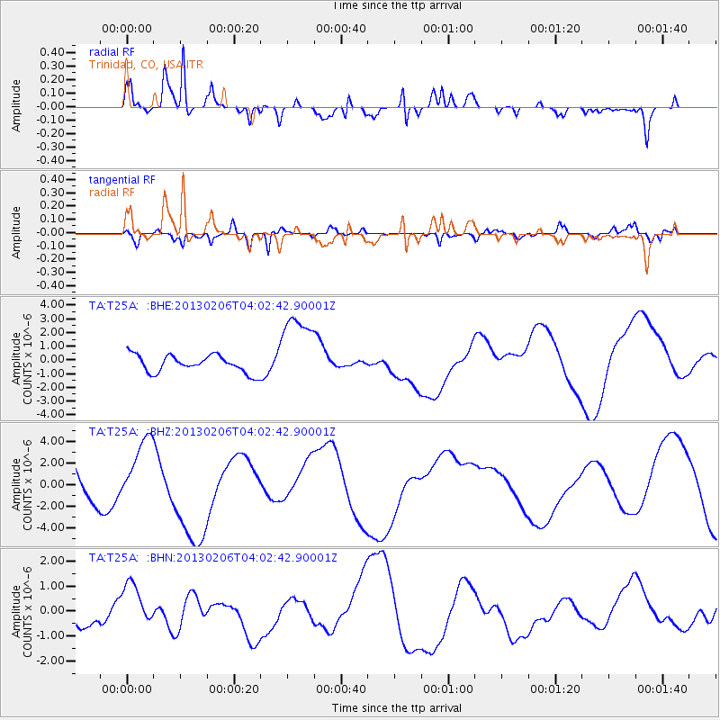
T25A Trinidad, CO, USA - Earthquake Result Viewer
*The percent match for this event was below the threshold and hence no stack was calculated.
| Earthquake location: |
Santa Cruz Islands |
| Earthquake latitude/longitude: |
-10.9/165.5 |
| Earthquake time(UTC): |
2013/02/06 (037) 03:49:44 GMT |
| Earthquake Depth: |
10 km |
| Earthquake Magnitude: |
5.5 MB |
| Earthquake Catalog/Contributor: |
WHDF/NEIC |
|
| Network: |
TA USArray Transportable Network (new EarthScope stations) |
| Station: |
T25A Trinidad, CO, USA |
| Lat/Lon: |
37.14 N/104.41 W |
| Elevation: |
2017 m |
|
| Distance: |
96.6 deg |
| Az: |
53.55 deg |
| Baz: |
261.361 deg |
| Ray Param: |
$rayparam |
*The percent match for this event was below the threshold and hence was not used in the summary stack. |
|
| Radial Match: |
70.98901 % |
| Radial Bump: |
400 |
| Transverse Match: |
55.891872 % |
| Transverse Bump: |
400 |
| SOD ConfigId: |
494114 |
| Insert Time: |
2013-05-01 06:38:57.168 +0000 |
| GWidth: |
2.5 |
| Max Bumps: |
400 |
| Tol: |
0.001 |
|
Signal To Noise
| Channel | StoN | STA | LTA |
| TA:T25A: :BHZ:20130206T04:02:42.90001Z | 2.0108597 | 3.2818439E-6 | 1.6320602E-6 |
| TA:T25A: :BHN:20130206T04:02:42.90001Z | 1.0006137 | 9.4298946E-7 | 9.4241113E-7 |
| TA:T25A: :BHE:20130206T04:02:42.90001Z | 4.4983516 | 2.8316267E-6 | 6.29481E-7 |
| Arrivals |
| Ps | |
| PpPs | |
| PsPs/PpSs | |


