You are here: Home > Network List > IU - Global Seismograph Network (GSN - IRIS/USGS) Stations List
> Station RSSD Black Hills, South Dakota, USA > Earthquake Result Viewer
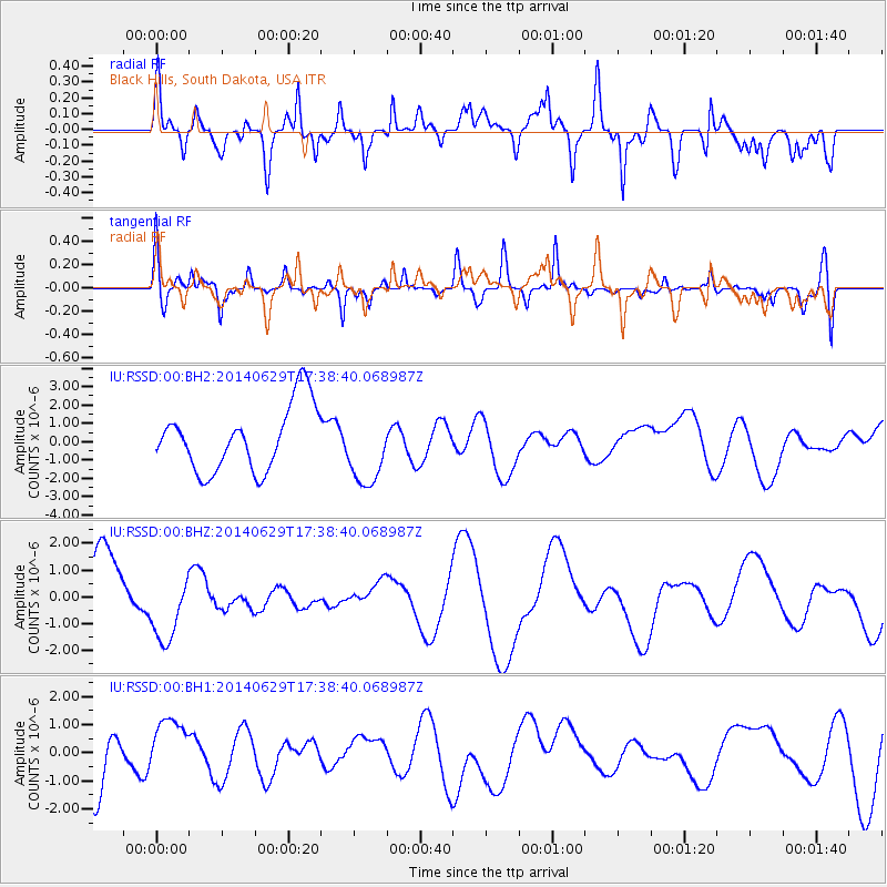
RSSD Black Hills, South Dakota, USA - Earthquake Result Viewer
*The percent match for this event was below the threshold and hence no stack was calculated.
| Earthquake location: |
Eastern Caucasus |
| Earthquake latitude/longitude: |
41.6/46.6 |
| Earthquake time(UTC): |
2014/06/29 (180) 17:26:09 GMT |
| Earthquake Depth: |
18 km |
| Earthquake Magnitude: |
5.0 mb |
| Earthquake Catalog/Contributor: |
ISC/ISC |
|
| Network: |
IU Global Seismograph Network (GSN - IRIS/USGS) |
| Station: |
RSSD Black Hills, South Dakota, USA |
| Lat/Lon: |
44.12 N/104.04 W |
| Elevation: |
2090 m |
|
| Distance: |
90.7 deg |
| Az: |
339.32 deg |
| Baz: |
21.589 deg |
| Ray Param: |
$rayparam |
*The percent match for this event was below the threshold and hence was not used in the summary stack. |
|
| Radial Match: |
60.132008 % |
| Radial Bump: |
400 |
| Transverse Match: |
49.311302 % |
| Transverse Bump: |
346 |
| SOD ConfigId: |
3390531 |
| Insert Time: |
2019-04-12 14:45:47.037 +0000 |
| GWidth: |
2.5 |
| Max Bumps: |
400 |
| Tol: |
0.001 |
|
Signal To Noise
| Channel | StoN | STA | LTA |
| IU:RSSD:00:BHZ:20140629T17:38:40.068987Z | 1.5107944 | 1.3471537E-6 | 8.9168566E-7 |
| IU:RSSD:00:BH1:20140629T17:38:40.068987Z | 1.3946441 | 1.043918E-6 | 7.485193E-7 |
| IU:RSSD:00:BH2:20140629T17:38:40.068987Z | 1.1322018 | 1.9884603E-6 | 1.7562774E-6 |
| Arrivals |
| Ps | |
| PpPs | |
| PsPs/PpSs | |


