You are here: Home > Network List > G - GEOSCOPE Stations List
> Station INU Inuyama, Japan > Earthquake Result Viewer
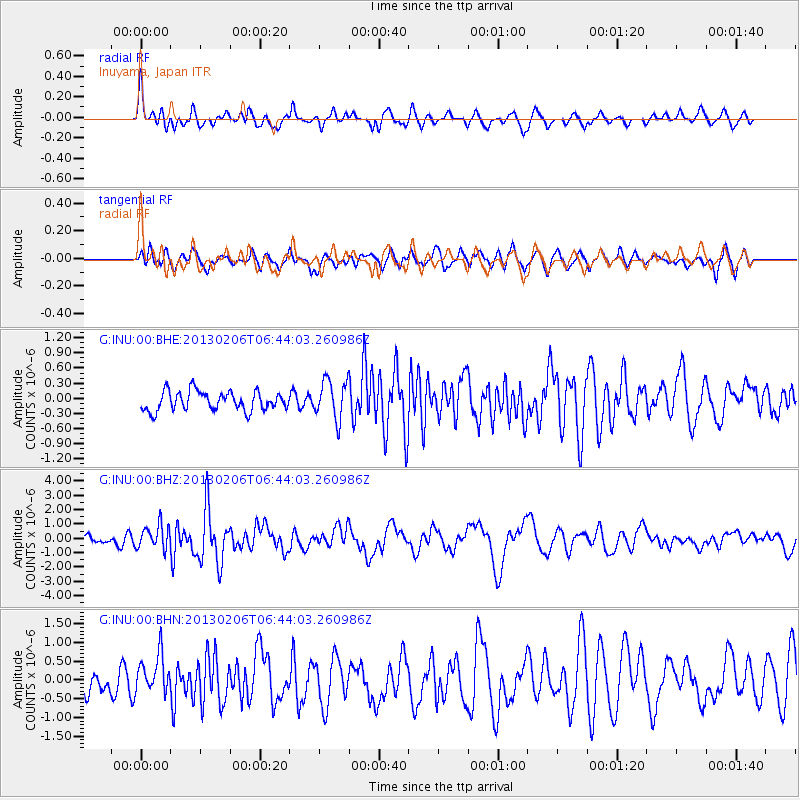
INU Inuyama, Japan - Earthquake Result Viewer
*The percent match for this event was below the threshold and hence no stack was calculated.
| Earthquake location: |
Santa Cruz Islands Region |
| Earthquake latitude/longitude: |
-10.8/164.6 |
| Earthquake time(UTC): |
2013/02/06 (037) 06:35:19 GMT |
| Earthquake Depth: |
10 km |
| Earthquake Magnitude: |
5.7 MB, 5.9 MS, 6.1 MW |
| Earthquake Catalog/Contributor: |
WHDF/NEIC |
|
| Network: |
G GEOSCOPE |
| Station: |
INU Inuyama, Japan |
| Lat/Lon: |
35.35 N/137.03 E |
| Elevation: |
132 m |
|
| Distance: |
52.8 deg |
| Az: |
331.674 deg |
| Baz: |
145.228 deg |
| Ray Param: |
$rayparam |
*The percent match for this event was below the threshold and hence was not used in the summary stack. |
|
| Radial Match: |
69.57316 % |
| Radial Bump: |
383 |
| Transverse Match: |
59.652134 % |
| Transverse Bump: |
400 |
| SOD ConfigId: |
494114 |
| Insert Time: |
2013-05-01 06:44:25.632 +0000 |
| GWidth: |
2.5 |
| Max Bumps: |
400 |
| Tol: |
0.001 |
|
Signal To Noise
| Channel | StoN | STA | LTA |
| G:INU:00:BHZ:20130206T06:44:03.260986Z | 2.7763526 | 8.4075407E-7 | 3.0282683E-7 |
| G:INU:00:BHN:20130206T06:44:03.260986Z | 1.3082496 | 4.8635775E-7 | 3.7176218E-7 |
| G:INU:00:BHE:20130206T06:44:03.260986Z | 2.0886118 | 3.9018695E-7 | 1.8681642E-7 |
| Arrivals |
| Ps | |
| PpPs | |
| PsPs/PpSs | |


