You are here: Home > Network List > TA - USArray Transportable Network (new EarthScope stations) Stations List
> Station N02D Trinity Center, CA, USA > Earthquake Result Viewer
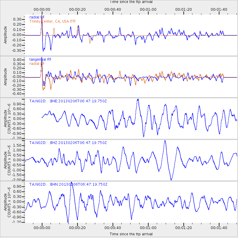
N02D Trinity Center, CA, USA - Earthquake Result Viewer
*The percent match for this event was below the threshold and hence no stack was calculated.
| Earthquake location: |
Santa Cruz Islands Region |
| Earthquake latitude/longitude: |
-10.8/164.6 |
| Earthquake time(UTC): |
2013/02/06 (037) 06:35:19 GMT |
| Earthquake Depth: |
10 km |
| Earthquake Magnitude: |
5.7 MB, 5.9 MS, 6.1 MW |
| Earthquake Catalog/Contributor: |
WHDF/NEIC |
|
| Network: |
TA USArray Transportable Network (new EarthScope stations) |
| Station: |
N02D Trinity Center, CA, USA |
| Lat/Lon: |
40.97 N/122.71 W |
| Elevation: |
937 m |
|
| Distance: |
84.3 deg |
| Az: |
46.609 deg |
| Baz: |
250.557 deg |
| Ray Param: |
$rayparam |
*The percent match for this event was below the threshold and hence was not used in the summary stack. |
|
| Radial Match: |
44.284996 % |
| Radial Bump: |
400 |
| Transverse Match: |
45.77765 % |
| Transverse Bump: |
400 |
| SOD ConfigId: |
494114 |
| Insert Time: |
2013-05-01 06:46:29.581 +0000 |
| GWidth: |
2.5 |
| Max Bumps: |
400 |
| Tol: |
0.001 |
|
Signal To Noise
| Channel | StoN | STA | LTA |
| TA:N02D: :BHZ:20130206T06:47:19.750Z | 1.031906 | 2.8431742E-7 | 2.7552647E-7 |
| TA:N02D: :BHN:20130206T06:47:19.750Z | 0.76227266 | 3.3721636E-7 | 4.4238286E-7 |
| TA:N02D: :BHE:20130206T06:47:19.750Z | 1.6159116 | 3.8702856E-7 | 2.3951097E-7 |
| Arrivals |
| Ps | |
| PpPs | |
| PsPs/PpSs | |


