You are here: Home > Network List > TA - USArray Transportable Network (new EarthScope stations) Stations List
> Station J01E Myrtle Point, OR, USA > Earthquake Result Viewer
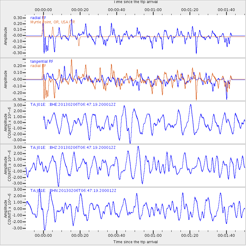
J01E Myrtle Point, OR, USA - Earthquake Result Viewer
*The percent match for this event was below the threshold and hence no stack was calculated.
| Earthquake location: |
Santa Cruz Islands Region |
| Earthquake latitude/longitude: |
-10.8/164.6 |
| Earthquake time(UTC): |
2013/02/06 (037) 06:35:19 GMT |
| Earthquake Depth: |
10 km |
| Earthquake Magnitude: |
5.7 MB, 5.9 MS, 6.1 MW |
| Earthquake Catalog/Contributor: |
WHDF/NEIC |
|
| Network: |
TA USArray Transportable Network (new EarthScope stations) |
| Station: |
J01E Myrtle Point, OR, USA |
| Lat/Lon: |
43.16 N/123.93 W |
| Elevation: |
128 m |
|
| Distance: |
84.2 deg |
| Az: |
44.231 deg |
| Baz: |
249.5 deg |
| Ray Param: |
$rayparam |
*The percent match for this event was below the threshold and hence was not used in the summary stack. |
|
| Radial Match: |
59.188683 % |
| Radial Bump: |
400 |
| Transverse Match: |
44.08171 % |
| Transverse Bump: |
400 |
| SOD ConfigId: |
494114 |
| Insert Time: |
2013-05-01 06:46:53.799 +0000 |
| GWidth: |
2.5 |
| Max Bumps: |
400 |
| Tol: |
0.001 |
|
Signal To Noise
| Channel | StoN | STA | LTA |
| TA:J01E: :BHZ:20130206T06:47:19.200012Z | 0.5191976 | 7.2265686E-7 | 1.3918725E-6 |
| TA:J01E: :BHN:20130206T06:47:19.200012Z | 2.6455326 | 1.8254547E-6 | 6.900141E-7 |
| TA:J01E: :BHE:20130206T06:47:19.200012Z | 0.9168761 | 9.168521E-7 | 9.999738E-7 |
| Arrivals |
| Ps | |
| PpPs | |
| PsPs/PpSs | |


