You are here: Home > Network List > AU - Australian Seismological Centre Stations List
> Station FORT Forrest, WA > Earthquake Result Viewer
FORT Forrest, WA - Earthquake Result Viewer
| Earthquake location: |
Santa Cruz Islands |
| Earthquake latitude/longitude: |
-10.9/165.3 |
| Earthquake time(UTC): |
2013/02/06 (037) 10:20:34 GMT |
| Earthquake Depth: |
10 km |
| Earthquake Magnitude: |
5.5 MB, 5.9 MS, 5.9 MW, 5.9 MW |
| Earthquake Catalog/Contributor: |
WHDF/NEIC |
|
| Network: |
AU Australian Seismological Centre |
| Station: |
FORT Forrest, WA |
| Lat/Lon: |
30.78 S/128.06 E |
| Elevation: |
165 m |
|
| Distance: |
39.8 deg |
| Az: |
234.446 deg |
| Baz: |
68.219 deg |
| Ray Param: |
0.07479106 |
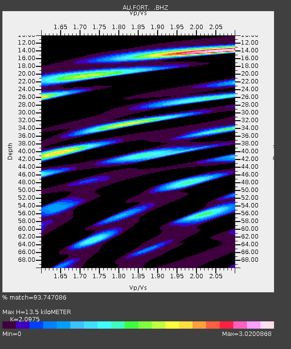
| Estimated Moho Depth: |
13.5 km |
| Estimated Crust Vp/Vs: |
2.10 |
| Assumed Crust Vp: |
6.479 km/s |
| Estimated Crust Vs: |
3.089 km/s |
| Estimated Crust Poisson's Ratio: |
0.35 |
|
| Radial Match: |
93.747086 % |
| Radial Bump: |
357 |
| Transverse Match: |
74.49036 % |
| Transverse Bump: |
400 |
| SOD ConfigId: |
494114 |
| Insert Time: |
2013-05-01 06:58:03.480 +0000 |
| GWidth: |
2.5 |
| Max Bumps: |
400 |
| Tol: |
0.001 |
|

Signal To Noise
| Channel | StoN | STA | LTA |
| AU:FORT: :BHZ:20130206T10:27:36.369998Z | 12.254354 | 2.8948357E-6 | 2.3622918E-7 |
| AU:FORT: :BHN:20130206T10:27:36.369998Z | 8.334968 | 1.6648747E-6 | 1.9974578E-7 |
| AU:FORT: :BHE:20130206T10:27:36.369998Z | 11.750572 | 3.7461675E-6 | 3.1880722E-7 |
| Arrivals |
| Ps | 2.4 SECOND |
| PpPs | 6.1 SECOND |
| PsPs/PpSs | 8.5 SECOND |


