You are here: Home > Network List > AZ - ANZA Regional Network Stations List
> Station SMER AZ.SMER > Earthquake Result Viewer
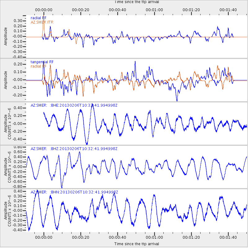
SMER AZ.SMER - Earthquake Result Viewer
*The percent match for this event was below the threshold and hence no stack was calculated.
| Earthquake location: |
Santa Cruz Islands |
| Earthquake latitude/longitude: |
-10.9/165.3 |
| Earthquake time(UTC): |
2013/02/06 (037) 10:20:34 GMT |
| Earthquake Depth: |
10 km |
| Earthquake Magnitude: |
5.5 MB, 5.9 MS, 5.9 MW, 5.9 MW |
| Earthquake Catalog/Contributor: |
WHDF/NEIC |
|
| Network: |
AZ ANZA Regional Network |
| Station: |
SMER AZ.SMER |
| Lat/Lon: |
33.46 N/117.17 W |
| Elevation: |
355 m |
|
| Distance: |
85.7 deg |
| Az: |
54.947 deg |
| Baz: |
254.142 deg |
| Ray Param: |
$rayparam |
*The percent match for this event was below the threshold and hence was not used in the summary stack. |
|
| Radial Match: |
51.091835 % |
| Radial Bump: |
387 |
| Transverse Match: |
68.75178 % |
| Transverse Bump: |
400 |
| SOD ConfigId: |
494114 |
| Insert Time: |
2013-05-01 06:59:51.062 +0000 |
| GWidth: |
2.5 |
| Max Bumps: |
400 |
| Tol: |
0.001 |
|
Signal To Noise
| Channel | StoN | STA | LTA |
| AZ:SMER: :BHZ:20130206T10:32:41.994998Z | 1.4807677 | 3.704626E-7 | 2.5018278E-7 |
| AZ:SMER: :BHN:20130206T10:32:41.994998Z | 0.90752864 | 2.1892433E-7 | 2.412313E-7 |
| AZ:SMER: :BHE:20130206T10:32:41.994998Z | 0.5306761 | 1.2533613E-7 | 2.3618195E-7 |
| Arrivals |
| Ps | |
| PpPs | |
| PsPs/PpSs | |


