You are here: Home > Network List > TA - USArray Transportable Network (new EarthScope stations) Stations List
> Station J01E Myrtle Point, OR, USA > Earthquake Result Viewer
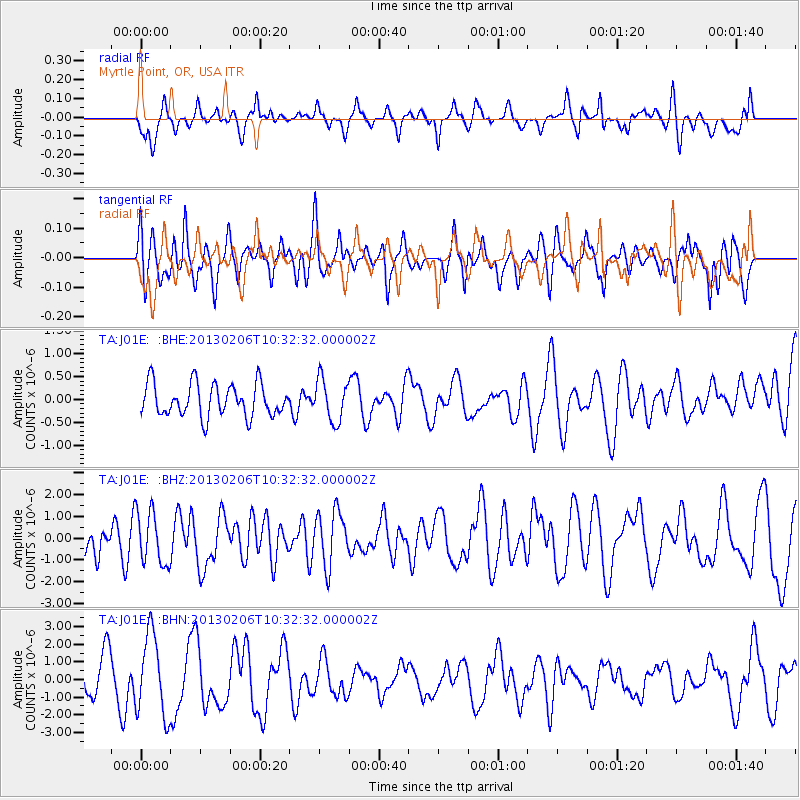
J01E Myrtle Point, OR, USA - Earthquake Result Viewer
*The percent match for this event was below the threshold and hence no stack was calculated.
| Earthquake location: |
Santa Cruz Islands |
| Earthquake latitude/longitude: |
-10.9/165.3 |
| Earthquake time(UTC): |
2013/02/06 (037) 10:20:34 GMT |
| Earthquake Depth: |
10 km |
| Earthquake Magnitude: |
5.5 MB, 5.9 MS, 5.9 MW, 5.9 MW |
| Earthquake Catalog/Contributor: |
WHDF/NEIC |
|
| Network: |
TA USArray Transportable Network (new EarthScope stations) |
| Station: |
J01E Myrtle Point, OR, USA |
| Lat/Lon: |
43.16 N/123.93 W |
| Elevation: |
128 m |
|
| Distance: |
83.7 deg |
| Az: |
44.039 deg |
| Baz: |
248.948 deg |
| Ray Param: |
$rayparam |
*The percent match for this event was below the threshold and hence was not used in the summary stack. |
|
| Radial Match: |
47.625328 % |
| Radial Bump: |
400 |
| Transverse Match: |
42.626045 % |
| Transverse Bump: |
396 |
| SOD ConfigId: |
494114 |
| Insert Time: |
2013-05-01 07:05:57.149 +0000 |
| GWidth: |
2.5 |
| Max Bumps: |
400 |
| Tol: |
0.001 |
|
Signal To Noise
| Channel | StoN | STA | LTA |
| TA:J01E: :BHZ:20130206T10:32:32.000002Z | 0.83097315 | 1.2089338E-6 | 1.4548409E-6 |
| TA:J01E: :BHN:20130206T10:32:32.000002Z | 2.472715 | 2.2904476E-6 | 9.262885E-7 |
| TA:J01E: :BHE:20130206T10:32:32.000002Z | 1.2771429 | 4.552132E-7 | 3.5643092E-7 |
| Arrivals |
| Ps | |
| PpPs | |
| PsPs/PpSs | |


