You are here: Home > Network List > TA - USArray Transportable Network (new EarthScope stations) Stations List
> Station X43A Marvell, AR, USA > Earthquake Result Viewer
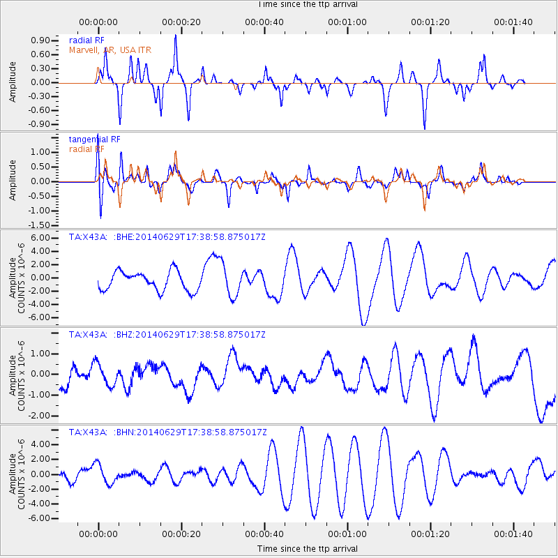
X43A Marvell, AR, USA - Earthquake Result Viewer
*The percent match for this event was below the threshold and hence no stack was calculated.
| Earthquake location: |
Eastern Caucasus |
| Earthquake latitude/longitude: |
41.6/46.6 |
| Earthquake time(UTC): |
2014/06/29 (180) 17:26:09 GMT |
| Earthquake Depth: |
18 km |
| Earthquake Magnitude: |
5.0 mb |
| Earthquake Catalog/Contributor: |
ISC/ISC |
|
| Network: |
TA USArray Transportable Network (new EarthScope stations) |
| Station: |
X43A Marvell, AR, USA |
| Lat/Lon: |
34.52 N/90.88 W |
| Elevation: |
53 m |
|
| Distance: |
94.8 deg |
| Az: |
325.946 deg |
| Baz: |
30.591 deg |
| Ray Param: |
$rayparam |
*The percent match for this event was below the threshold and hence was not used in the summary stack. |
|
| Radial Match: |
37.33764 % |
| Radial Bump: |
234 |
| Transverse Match: |
27.630795 % |
| Transverse Bump: |
322 |
| SOD ConfigId: |
3390531 |
| Insert Time: |
2019-04-12 14:48:37.012 +0000 |
| GWidth: |
2.5 |
| Max Bumps: |
400 |
| Tol: |
0.001 |
|
Signal To Noise
| Channel | StoN | STA | LTA |
| TA:X43A: :BHZ:20140629T17:38:58.875017Z | 0.99776477 | 5.1705905E-7 | 5.182174E-7 |
| TA:X43A: :BHN:20140629T17:38:58.875017Z | 2.267304 | 1.3190224E-6 | 5.8175806E-7 |
| TA:X43A: :BHE:20140629T17:38:58.875017Z | 1.7423345 | 2.4292506E-6 | 1.3942504E-6 |
| Arrivals |
| Ps | |
| PpPs | |
| PsPs/PpSs | |


