You are here: Home > Network List > CI - Caltech Regional Seismic Network Stations List
> Station FUR Furnace Creek, CA, USA > Earthquake Result Viewer
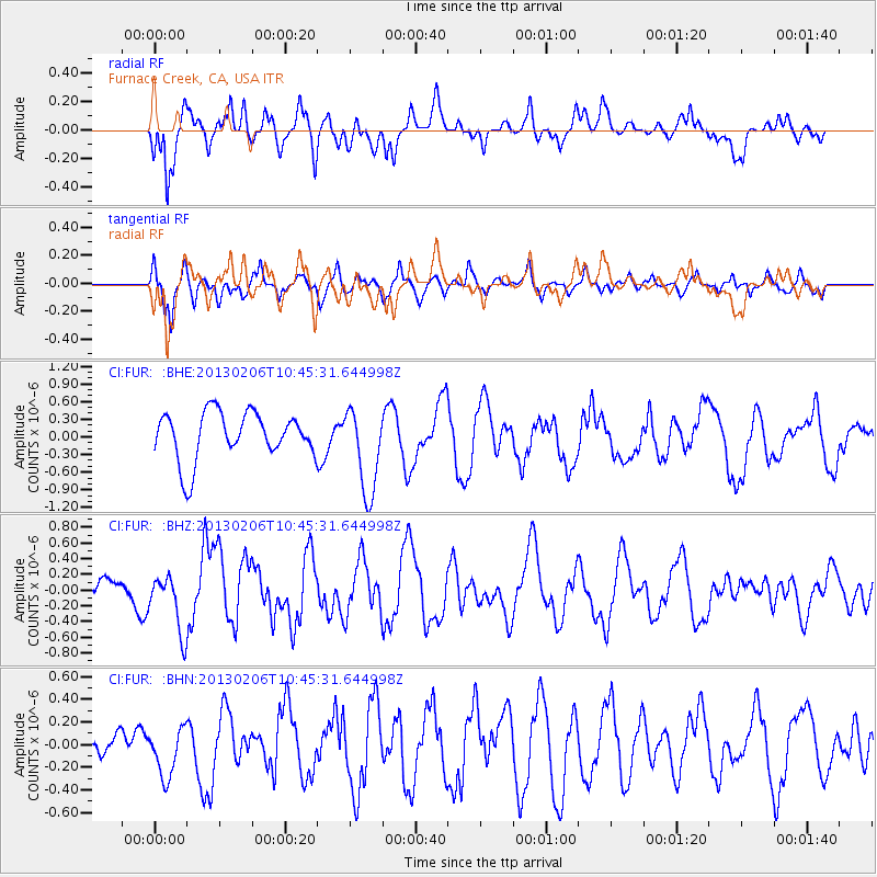
FUR Furnace Creek, CA, USA - Earthquake Result Viewer
*The percent match for this event was below the threshold and hence no stack was calculated.
| Earthquake location: |
Santa Cruz Islands Region |
| Earthquake latitude/longitude: |
-10.6/164.8 |
| Earthquake time(UTC): |
2013/02/06 (037) 10:33:17 GMT |
| Earthquake Depth: |
10 km |
| Earthquake Magnitude: |
5.7 MB, 5.8 MS, 6.0 MW, 5.9 MW |
| Earthquake Catalog/Contributor: |
WHDF/NEIC |
|
| Network: |
CI Caltech Regional Seismic Network |
| Station: |
FUR Furnace Creek, CA, USA |
| Lat/Lon: |
36.47 N/116.86 W |
| Elevation: |
-37.0 m |
|
| Distance: |
87.1 deg |
| Az: |
52.241 deg |
| Baz: |
254.603 deg |
| Ray Param: |
$rayparam |
*The percent match for this event was below the threshold and hence was not used in the summary stack. |
|
| Radial Match: |
53.51014 % |
| Radial Bump: |
400 |
| Transverse Match: |
68.763695 % |
| Transverse Bump: |
400 |
| SOD ConfigId: |
494114 |
| Insert Time: |
2013-05-01 07:10:19.793 +0000 |
| GWidth: |
2.5 |
| Max Bumps: |
400 |
| Tol: |
0.001 |
|
Signal To Noise
| Channel | StoN | STA | LTA |
| CI:FUR: :BHZ:20130206T10:45:31.644998Z | 1.8410027 | 3.7239002E-7 | 2.0227566E-7 |
| CI:FUR: :BHN:20130206T10:45:31.644998Z | 1.007758 | 2.2129149E-7 | 2.1958793E-7 |
| CI:FUR: :BHE:20130206T10:45:31.644998Z | 1.8265932 | 7.4015975E-7 | 4.0521323E-7 |
| Arrivals |
| Ps | |
| PpPs | |
| PsPs/PpSs | |


