You are here: Home > Network List > TA - USArray Transportable Network (new EarthScope stations) Stations List
> Station Z41A Richland Creek Farm, El Dorado, AR, USA > Earthquake Result Viewer
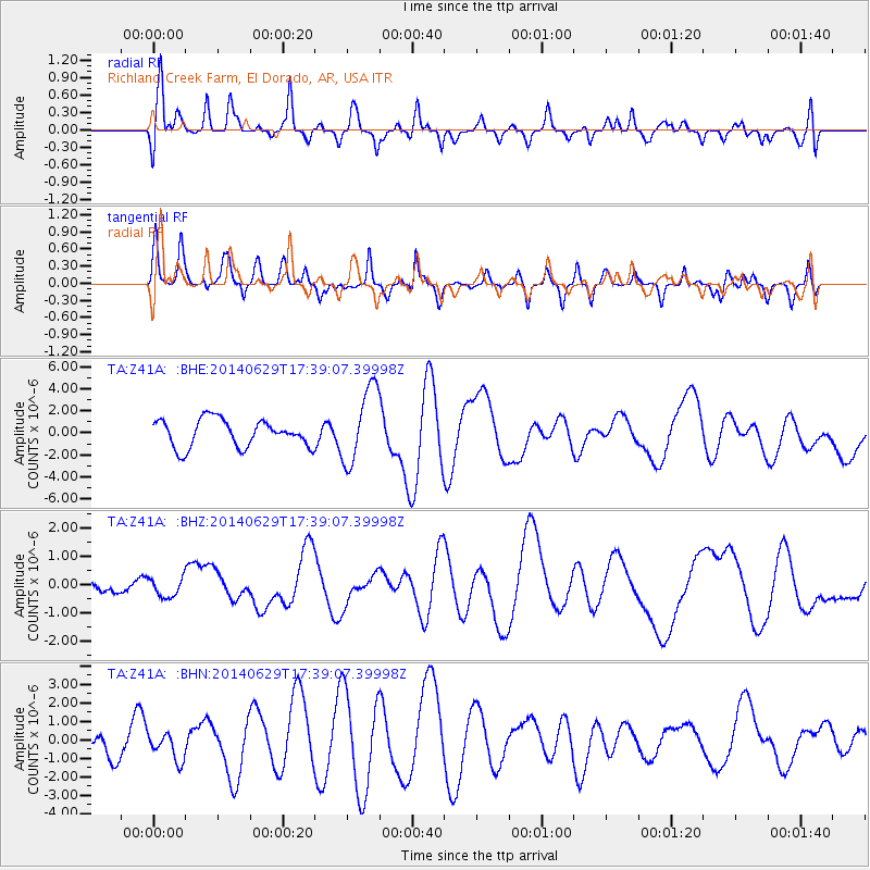
Z41A Richland Creek Farm, El Dorado, AR, USA - Earthquake Result Viewer
*The percent match for this event was below the threshold and hence no stack was calculated.
| Earthquake location: |
Eastern Caucasus |
| Earthquake latitude/longitude: |
41.6/46.6 |
| Earthquake time(UTC): |
2014/06/29 (180) 17:26:09 GMT |
| Earthquake Depth: |
18 km |
| Earthquake Magnitude: |
5.0 mb |
| Earthquake Catalog/Contributor: |
ISC/ISC |
|
| Network: |
TA USArray Transportable Network (new EarthScope stations) |
| Station: |
Z41A Richland Creek Farm, El Dorado, AR, USA |
| Lat/Lon: |
33.26 N/92.80 W |
| Elevation: |
62 m |
|
| Distance: |
96.7 deg |
| Az: |
326.705 deg |
| Baz: |
29.448 deg |
| Ray Param: |
$rayparam |
*The percent match for this event was below the threshold and hence was not used in the summary stack. |
|
| Radial Match: |
44.046684 % |
| Radial Bump: |
400 |
| Transverse Match: |
34.99629 % |
| Transverse Bump: |
380 |
| SOD ConfigId: |
3390531 |
| Insert Time: |
2019-04-12 14:48:40.602 +0000 |
| GWidth: |
2.5 |
| Max Bumps: |
400 |
| Tol: |
0.001 |
|
Signal To Noise
| Channel | StoN | STA | LTA |
| TA:Z41A: :BHZ:20140629T17:39:07.39998Z | 1.5327299 | 3.172785E-7 | 2.0700223E-7 |
| TA:Z41A: :BHN:20140629T17:39:07.39998Z | 1.3323854 | 7.5122915E-7 | 5.638227E-7 |
| TA:Z41A: :BHE:20140629T17:39:07.39998Z | 2.7933514 | 3.4710422E-6 | 1.2426085E-6 |
| Arrivals |
| Ps | |
| PpPs | |
| PsPs/PpSs | |


