You are here: Home > Network List > TA - USArray Transportable Network (new EarthScope stations) Stations List
> Station 109C Camp Elliot, Mirimar, CA, USA > Earthquake Result Viewer
109C Camp Elliot, Mirimar, CA, USA - Earthquake Result Viewer
*The percent match for this event was below the threshold and hence no stack was calculated.
| Earthquake location: |
Santa Cruz Islands |
| Earthquake latitude/longitude: |
-10.7/165.2 |
| Earthquake time(UTC): |
2013/02/06 (037) 11:03:45 GMT |
| Earthquake Depth: |
10 km |
| Earthquake Magnitude: |
5.6 MB, 5.6 MS, 5.8 MW |
| Earthquake Catalog/Contributor: |
WHDF/NEIC |
|
| Network: |
TA USArray Transportable Network (new EarthScope stations) |
| Station: |
109C Camp Elliot, Mirimar, CA, USA |
| Lat/Lon: |
32.89 N/117.11 W |
| Elevation: |
150 m |
|
| Distance: |
85.6 deg |
| Az: |
55.538 deg |
| Baz: |
254.38 deg |
| Ray Param: |
$rayparam |
*The percent match for this event was below the threshold and hence was not used in the summary stack. |
|
| Radial Match: |
95.15373 % |
| Radial Bump: |
268 |
| Transverse Match: |
75.47011 % |
| Transverse Bump: |
400 |
| SOD ConfigId: |
494114 |
| Insert Time: |
2013-05-01 07:20:19.494 +0000 |
| GWidth: |
2.5 |
| Max Bumps: |
400 |
| Tol: |
0.001 |
|
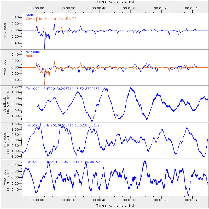
Signal To Noise
| Channel | StoN | STA | LTA |
| TA:109C: :BHZ:20130206T11:15:52.870015Z | 2.2244153 | 1.1494711E-6 | 5.16752E-7 |
| TA:109C: :BHN:20130206T11:15:52.870015Z | 1.1298398 | 3.143485E-7 | 2.7822398E-7 |
| TA:109C: :BHE:20130206T11:15:52.870015Z | 1.6710285 | 6.8607886E-7 | 4.1057282E-7 |
| Arrivals |
| Ps | |
| PpPs | |
| PsPs/PpSs | |


