You are here: Home > Network List > IW - Intermountain West Stations List
> Station MOOW Moose Ponds, Wyoming, USA > Earthquake Result Viewer
MOOW Moose Ponds, Wyoming, USA - Earthquake Result Viewer
*The percent match for this event was below the threshold and hence no stack was calculated.
| Earthquake location: |
Santa Cruz Islands |
| Earthquake latitude/longitude: |
-10.8/166.5 |
| Earthquake time(UTC): |
2013/02/06 (037) 13:54:54 GMT |
| Earthquake Depth: |
14 km |
| Earthquake Magnitude: |
6.0 MB, 5.7 MS, 5.8 MW, 5.8 MW |
| Earthquake Catalog/Contributor: |
WHDF/NEIC |
|
| Network: |
IW Intermountain West |
| Station: |
MOOW Moose Ponds, Wyoming, USA |
| Lat/Lon: |
43.75 N/110.74 W |
| Elevation: |
2128 m |
|
| Distance: |
92.2 deg |
| Az: |
46.005 deg |
| Baz: |
257.241 deg |
| Ray Param: |
$rayparam |
*The percent match for this event was below the threshold and hence was not used in the summary stack. |
|
| Radial Match: |
56.365093 % |
| Radial Bump: |
400 |
| Transverse Match: |
76.10476 % |
| Transverse Bump: |
387 |
| SOD ConfigId: |
494114 |
| Insert Time: |
2013-05-01 07:51:22.922 +0000 |
| GWidth: |
2.5 |
| Max Bumps: |
400 |
| Tol: |
0.001 |
|
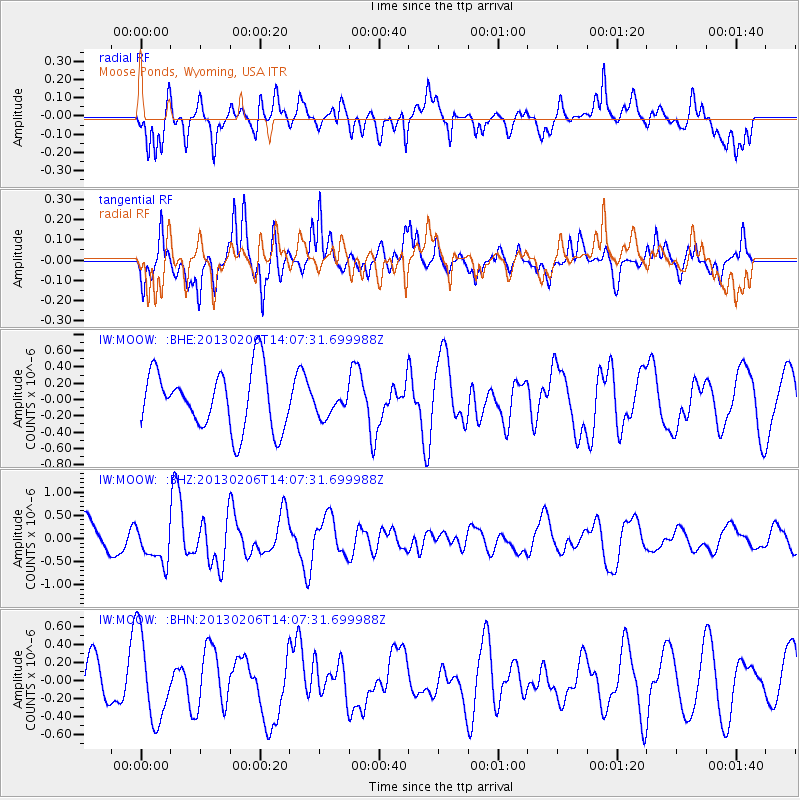
Signal To Noise
| Channel | StoN | STA | LTA |
| IW:MOOW: :BHZ:20130206T14:07:31.699988Z | 1.4208152 | 4.041013E-7 | 2.844151E-7 |
| IW:MOOW: :BHN:20130206T14:07:31.699988Z | 1.9025027 | 4.7209664E-7 | 2.4814506E-7 |
| IW:MOOW: :BHE:20130206T14:07:31.699988Z | 0.40268964 | 1.465001E-7 | 3.63804E-7 |
| Arrivals |
| Ps | |
| PpPs | |
| PsPs/PpSs | |


