You are here: Home > Network List > TA - USArray Transportable Network (new EarthScope stations) Stations List
> Station G05D Wamic, OR, USA > Earthquake Result Viewer
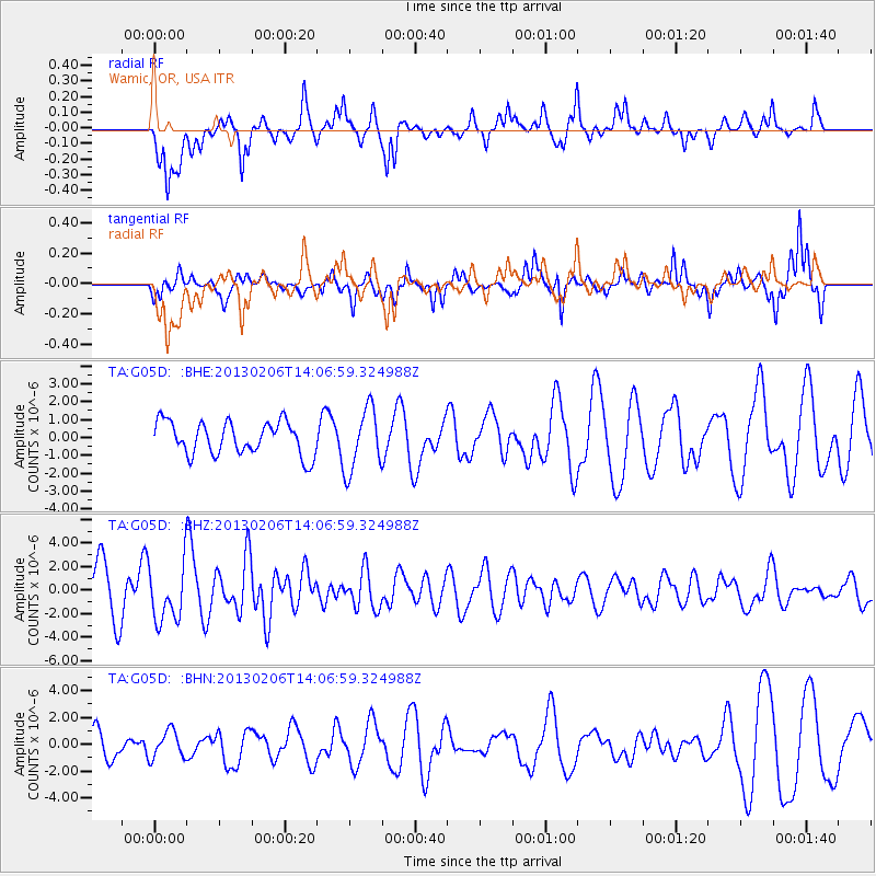
G05D Wamic, OR, USA - Earthquake Result Viewer
*The percent match for this event was below the threshold and hence no stack was calculated.
| Earthquake location: |
Santa Cruz Islands |
| Earthquake latitude/longitude: |
-10.8/166.5 |
| Earthquake time(UTC): |
2013/02/06 (037) 13:54:54 GMT |
| Earthquake Depth: |
14 km |
| Earthquake Magnitude: |
6.0 MB, 5.7 MS, 5.8 MW, 5.8 MW |
| Earthquake Catalog/Contributor: |
WHDF/NEIC |
|
| Network: |
TA USArray Transportable Network (new EarthScope stations) |
| Station: |
G05D Wamic, OR, USA |
| Lat/Lon: |
45.24 N/121.32 W |
| Elevation: |
592 m |
|
| Distance: |
85.4 deg |
| Az: |
42.432 deg |
| Baz: |
249.769 deg |
| Ray Param: |
$rayparam |
*The percent match for this event was below the threshold and hence was not used in the summary stack. |
|
| Radial Match: |
68.61271 % |
| Radial Bump: |
400 |
| Transverse Match: |
60.480415 % |
| Transverse Bump: |
314 |
| SOD ConfigId: |
494114 |
| Insert Time: |
2013-05-01 07:52:47.719 +0000 |
| GWidth: |
2.5 |
| Max Bumps: |
400 |
| Tol: |
0.001 |
|
Signal To Noise
| Channel | StoN | STA | LTA |
| TA:G05D: :BHZ:20130206T14:06:59.324988Z | 1.4885887 | 2.387128E-6 | 1.6036183E-6 |
| TA:G05D: :BHN:20130206T14:06:59.324988Z | 0.76225835 | 1.0207997E-6 | 1.339178E-6 |
| TA:G05D: :BHE:20130206T14:06:59.324988Z | 1.9088949 | 1.7521285E-6 | 9.178758E-7 |
| Arrivals |
| Ps | |
| PpPs | |
| PsPs/PpSs | |


