You are here: Home > Network List > TA - USArray Transportable Network (new EarthScope stations) Stations List
> Station O03E Paynes Creek, CA, USA > Earthquake Result Viewer
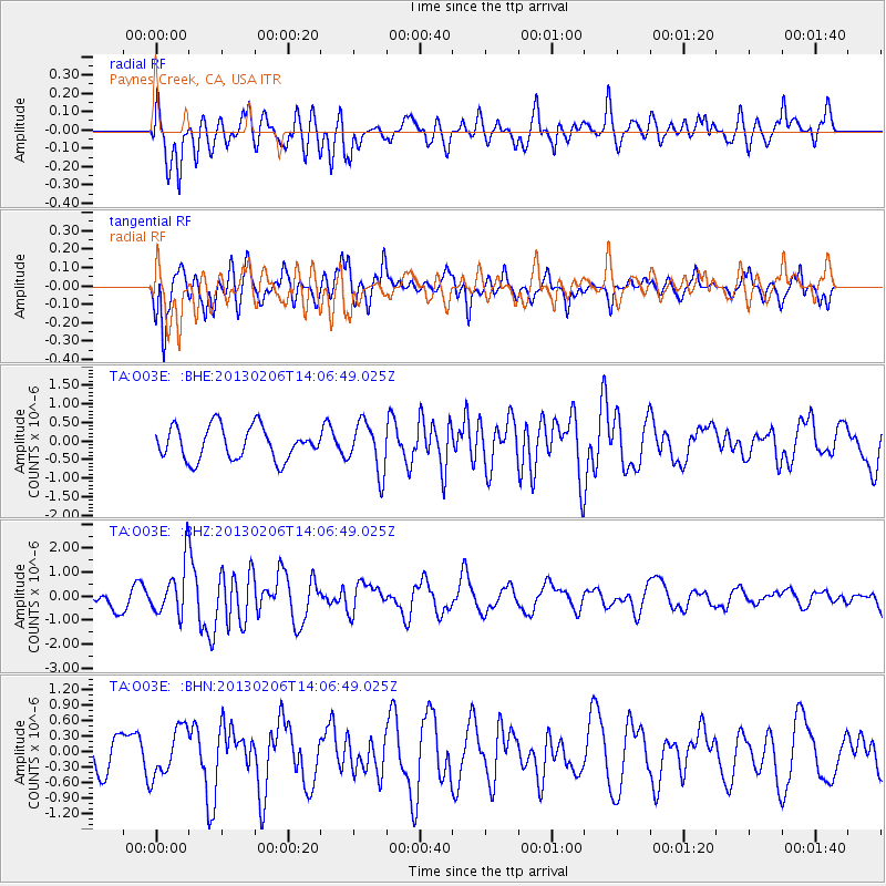
O03E Paynes Creek, CA, USA - Earthquake Result Viewer
*The percent match for this event was below the threshold and hence no stack was calculated.
| Earthquake location: |
Santa Cruz Islands |
| Earthquake latitude/longitude: |
-10.8/166.5 |
| Earthquake time(UTC): |
2013/02/06 (037) 13:54:54 GMT |
| Earthquake Depth: |
14 km |
| Earthquake Magnitude: |
6.0 MB, 5.7 MS, 5.8 MW, 5.8 MW |
| Earthquake Catalog/Contributor: |
WHDF/NEIC |
|
| Network: |
TA USArray Transportable Network (new EarthScope stations) |
| Station: |
O03E Paynes Creek, CA, USA |
| Lat/Lon: |
40.29 N/121.80 W |
| Elevation: |
967 m |
|
| Distance: |
83.3 deg |
| Az: |
46.972 deg |
| Baz: |
249.888 deg |
| Ray Param: |
$rayparam |
*The percent match for this event was below the threshold and hence was not used in the summary stack. |
|
| Radial Match: |
55.492493 % |
| Radial Bump: |
400 |
| Transverse Match: |
66.969185 % |
| Transverse Bump: |
400 |
| SOD ConfigId: |
494114 |
| Insert Time: |
2013-05-01 07:53:31.307 +0000 |
| GWidth: |
2.5 |
| Max Bumps: |
400 |
| Tol: |
0.001 |
|
Signal To Noise
| Channel | StoN | STA | LTA |
| TA:O03E: :BHZ:20130206T14:06:49.025Z | 2.7767093 | 1.0738634E-6 | 3.8673957E-7 |
| TA:O03E: :BHN:20130206T14:06:49.025Z | 1.1286999 | 4.7069602E-7 | 4.1702495E-7 |
| TA:O03E: :BHE:20130206T14:06:49.025Z | 1.5185144 | 6.641841E-7 | 4.373907E-7 |
| Arrivals |
| Ps | |
| PpPs | |
| PsPs/PpSs | |


