You are here: Home > Network List > UW - Pacific Northwest Regional Seismic Network Stations List
> Station OMAK Colville Reservation, Omak, WA, USA > Earthquake Result Viewer
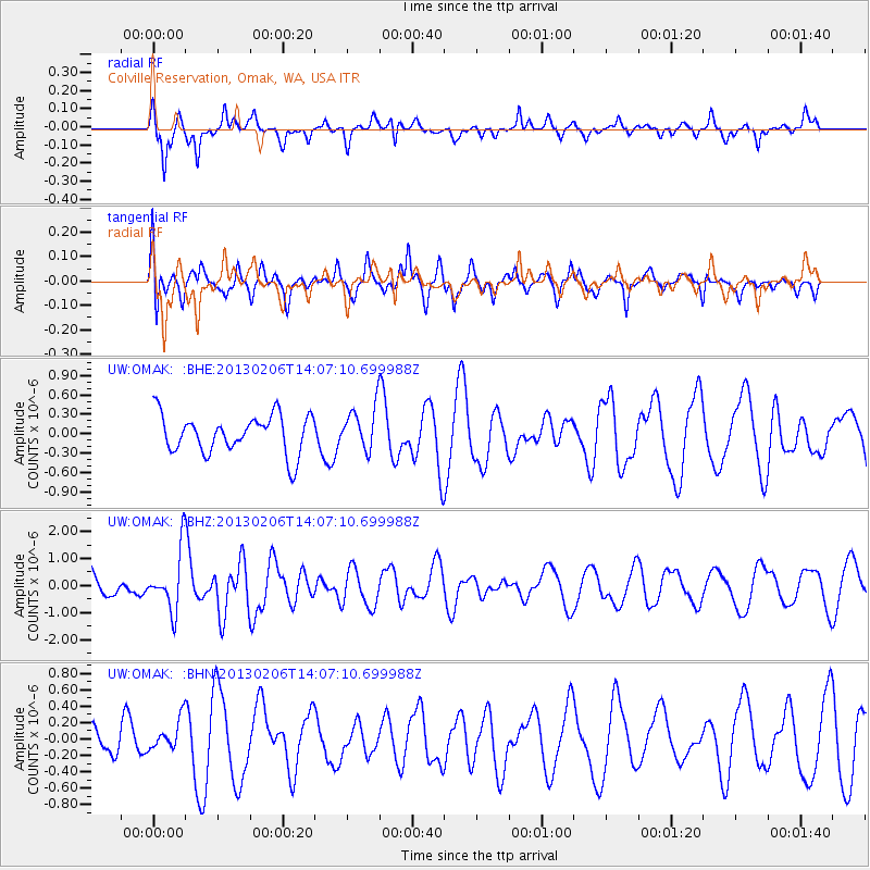
OMAK Colville Reservation, Omak, WA, USA - Earthquake Result Viewer
*The percent match for this event was below the threshold and hence no stack was calculated.
| Earthquake location: |
Santa Cruz Islands |
| Earthquake latitude/longitude: |
-10.8/166.5 |
| Earthquake time(UTC): |
2013/02/06 (037) 13:54:54 GMT |
| Earthquake Depth: |
14 km |
| Earthquake Magnitude: |
6.0 MB, 5.7 MS, 5.8 MW, 5.8 MW |
| Earthquake Catalog/Contributor: |
WHDF/NEIC |
|
| Network: |
UW Pacific Northwest Regional Seismic Network |
| Station: |
OMAK Colville Reservation, Omak, WA, USA |
| Lat/Lon: |
48.36 N/119.33 W |
| Elevation: |
696 m |
|
| Distance: |
87.7 deg |
| Az: |
39.948 deg |
| Baz: |
251.06 deg |
| Ray Param: |
$rayparam |
*The percent match for this event was below the threshold and hence was not used in the summary stack. |
|
| Radial Match: |
65.009514 % |
| Radial Bump: |
348 |
| Transverse Match: |
50.47235 % |
| Transverse Bump: |
368 |
| SOD ConfigId: |
494114 |
| Insert Time: |
2013-05-01 07:54:05.193 +0000 |
| GWidth: |
2.5 |
| Max Bumps: |
400 |
| Tol: |
0.001 |
|
Signal To Noise
| Channel | StoN | STA | LTA |
| UW:OMAK: :BHZ:20130206T14:07:10.699988Z | 2.8598237 | 1.0897097E-6 | 3.8104088E-7 |
| UW:OMAK: :BHN:20130206T14:07:10.699988Z | 1.021014 | 1.904272E-7 | 1.8650795E-7 |
| UW:OMAK: :BHE:20130206T14:07:10.699988Z | 1.1534015 | 3.4005842E-7 | 2.9483093E-7 |
| Arrivals |
| Ps | |
| PpPs | |
| PsPs/PpSs | |


