You are here: Home > Network List > GS - US Geological Survey Networks Stations List
> Station KAN13 Rinehart Farm > Earthquake Result Viewer
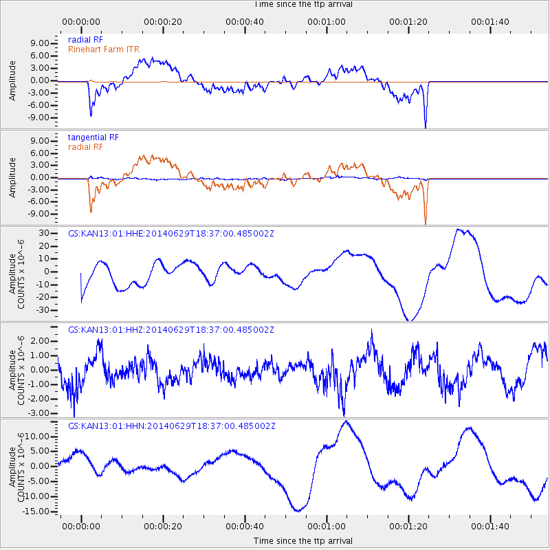
KAN13 Rinehart Farm - Earthquake Result Viewer
*The percent match for this event was below the threshold and hence no stack was calculated.
| Earthquake location: |
Tonga Islands |
| Earthquake latitude/longitude: |
-15.4/-175.4 |
| Earthquake time(UTC): |
2014/06/29 (180) 18:24:30 GMT |
| Earthquake Depth: |
10 km |
| Earthquake Magnitude: |
5.6 MB |
| Earthquake Catalog/Contributor: |
NEIC PDE/NEIC COMCAT |
|
| Network: |
GS US Geological Survey Networks |
| Station: |
KAN13 Rinehart Farm |
| Lat/Lon: |
37.01 N/97.48 W |
| Elevation: |
340 m |
|
| Distance: |
89.8 deg |
| Az: |
51.523 deg |
| Baz: |
250.659 deg |
| Ray Param: |
$rayparam |
*The percent match for this event was below the threshold and hence was not used in the summary stack. |
|
| Radial Match: |
44.991444 % |
| Radial Bump: |
400 |
| Transverse Match: |
49.00788 % |
| Transverse Bump: |
400 |
| SOD ConfigId: |
3390531 |
| Insert Time: |
2019-04-12 14:56:27.538 +0000 |
| GWidth: |
2.5 |
| Max Bumps: |
400 |
| Tol: |
0.001 |
|
Signal To Noise
| Channel | StoN | STA | LTA |
| GS:KAN13:01:HHZ:20140629T18:37:00.485002Z | 1.325855 | 1.1160083E-6 | 8.417273E-7 |
| GS:KAN13:01:HHN:20140629T18:37:00.485002Z | 1.3616086 | 4.574736E-6 | 3.3598026E-6 |
| GS:KAN13:01:HHE:20140629T18:37:00.485002Z | 0.8899616 | 7.667052E-6 | 8.615037E-6 |
| Arrivals |
| Ps | |
| PpPs | |
| PsPs/PpSs | |


