You are here: Home > Network List > TA - USArray Transportable Network (new EarthScope stations) Stations List
> Station O03E Paynes Creek, CA, USA > Earthquake Result Viewer
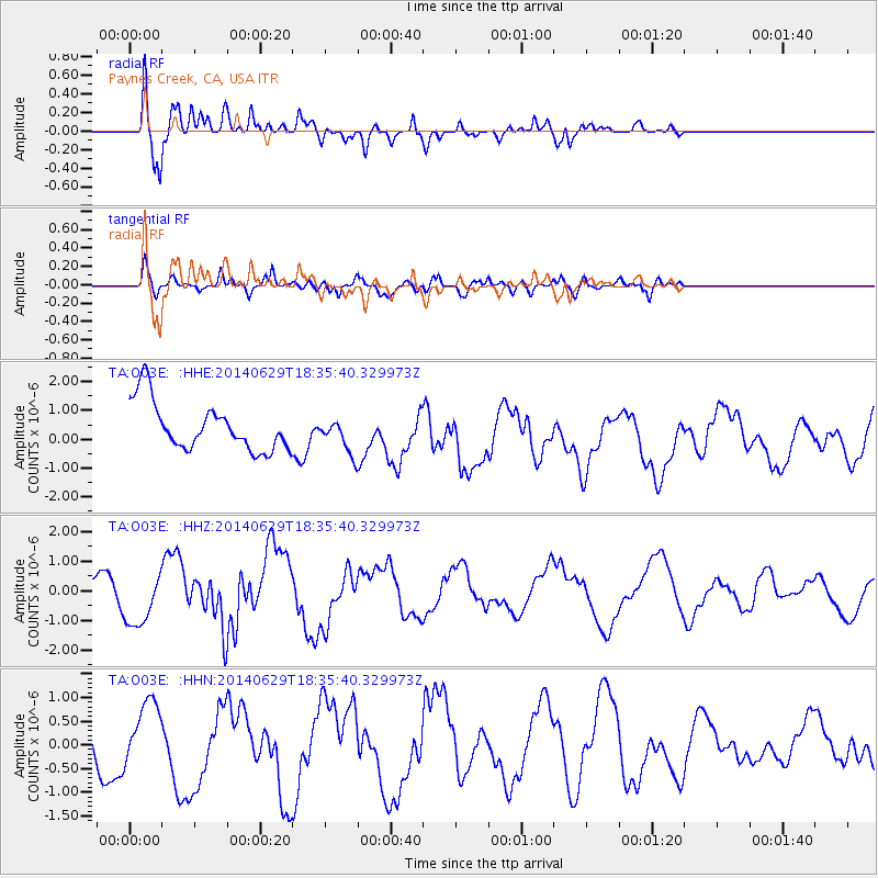
O03E Paynes Creek, CA, USA - Earthquake Result Viewer
*The percent match for this event was below the threshold and hence no stack was calculated.
| Earthquake location: |
Tonga Islands |
| Earthquake latitude/longitude: |
-15.4/-175.4 |
| Earthquake time(UTC): |
2014/06/29 (180) 18:24:30 GMT |
| Earthquake Depth: |
10 km |
| Earthquake Magnitude: |
5.6 MB |
| Earthquake Catalog/Contributor: |
NEIC PDE/NEIC COMCAT |
|
| Network: |
TA USArray Transportable Network (new EarthScope stations) |
| Station: |
O03E Paynes Creek, CA, USA |
| Lat/Lon: |
40.29 N/121.80 W |
| Elevation: |
967 m |
|
| Distance: |
74.5 deg |
| Az: |
39.744 deg |
| Baz: |
233.75 deg |
| Ray Param: |
$rayparam |
*The percent match for this event was below the threshold and hence was not used in the summary stack. |
|
| Radial Match: |
74.912025 % |
| Radial Bump: |
400 |
| Transverse Match: |
41.93296 % |
| Transverse Bump: |
400 |
| SOD ConfigId: |
3390531 |
| Insert Time: |
2019-04-12 14:58:18.421 +0000 |
| GWidth: |
2.5 |
| Max Bumps: |
400 |
| Tol: |
0.001 |
|
Signal To Noise
| Channel | StoN | STA | LTA |
| TA:O03E: :HHZ:20140629T18:35:40.329973Z | 1.2415054 | 9.657842E-7 | 7.7791384E-7 |
| TA:O03E: :HHN:20140629T18:35:40.329973Z | 0.8579604 | 5.809073E-7 | 6.770793E-7 |
| TA:O03E: :HHE:20140629T18:35:40.329973Z | 0.50811595 | 4.3472727E-7 | 8.5556707E-7 |
| Arrivals |
| Ps | |
| PpPs | |
| PsPs/PpSs | |


