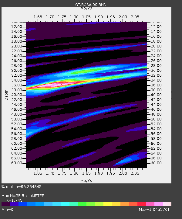
BOSA Boshof, South Africa - Earthquake Result Viewer
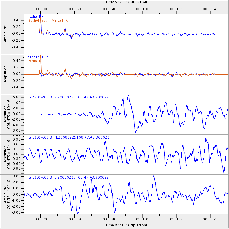
Earthquake location: Southern Sumatra, Indonesia
Earthquake latitude/longitude: -2.5/100.0
Earthquake time(UTC): 2008/02/25 (056) 08:36:33 GMT
Earthquake Depth: 25 km
Earthquake Magnitude: 6.4 MB, 7.3 MS, 7.0 MW, 6.9 MW
Earthquake Catalog/Contributor: WHDF/NEIC
Network: GT Global Telemetered Seismograph Network (USAF/USGS)
Station: BOSA Boshof, South Africa
Lat/Lon: 28.61 S/25.26 E
Elevation: 1280 m
Distance: 75.4 deg
Az: 241.213 deg
Baz: 84.807 deg
Ray Param: 0.05166471
Estimated Moho Depth: 35.5 km
Estimated Crust Vp/Vs: 1.75
Assumed Crust Vp: 6.459 km/s
Estimated Crust Vs: 3.702 km/s
Estimated Crust Poisson's Ratio: 0.26
Radial Match: 95.364845 %
Radial Bump: 338
Transverse Match: 81.53669 %
Transverse Bump: 400
SOD ConfigId: 2564
Insert Time: 2010-02-27 01:43:24.644 +0000
GWidth: 2.5
Max Bumps: 400
Tol: 0.001

Signal To Noise

ChannelStoNSTALTA
GT:BOSA:00:BHN:20080225T08:47:43.30002Z1.26620092.7008437E-72.1330294E-7
GT:BOSA:00:BHE:20080225T08:47:43.30002Z1.1163053.077489E-72.7568532E-7
GT:BOSA:00:BHZ:20080225T08:47:43.30002Z3.14787326.389627E-72.0298235E-7
Arrivals
Ps4.2 SECOND
PpPs15 SECOND
PsPs/PpSs19 SECOND