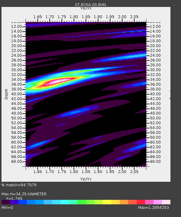
BOSA Boshof, South Africa - Earthquake Result Viewer
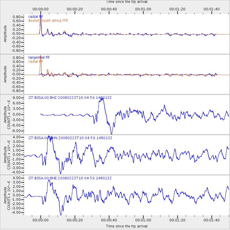
Earthquake location: South Sandwich Islands Region
Earthquake latitude/longitude: -57.3/-23.4
Earthquake time(UTC): 2008/02/23 (054) 15:57:19 GMT
Earthquake Depth: 10 km
Earthquake Magnitude: 6.2 MB, 6.7 MS, 6.7 MW, 6.7 MW
Earthquake Catalog/Contributor: WHDF/NEIC
Network: GT Global Telemetered Seismograph Network (USAF/USGS)
Station: BOSA Boshof, South Africa
Lat/Lon: 28.61 S/25.26 E
Elevation: 1280 m
Distance: 44.3 deg
Az: 70.85 deg
Baz: 215.648 deg
Ray Param: 0.071974546
Estimated Moho Depth: 34.25 km
Estimated Crust Vp/Vs: 1.75
Assumed Crust Vp: 6.459 km/s
Estimated Crust Vs: 3.702 km/s
Estimated Crust Poisson's Ratio: 0.26
Radial Match: 94.7579 %
Radial Bump: 386
Transverse Match: 73.92995 %
Transverse Bump: 400
SOD ConfigId: 2564
Insert Time: 2010-02-27 01:43:25.562 +0000
GWidth: 2.5
Max Bumps: 400
Tol: 0.001

Signal To Noise

ChannelStoNSTALTA
GT:BOSA:00:BHN:20080223T16:04:59.148013Z13.7947811.8900362E-61.3701097E-7
GT:BOSA:00:BHE:20080223T16:04:59.148013Z4.17530441.5347988E-63.6758965E-7
GT:BOSA:00:BHZ:20080223T16:04:59.148013Z13.2603963.4490479E-62.6010142E-7
Arrivals
Ps4.2 SECOND
PpPs14 SECOND
PsPs/PpSs18 SECOND