You are here: Home > Network List > CI - Caltech Regional Seismic Network Stations List
> Station MPP McPhearson Peak > Earthquake Result Viewer
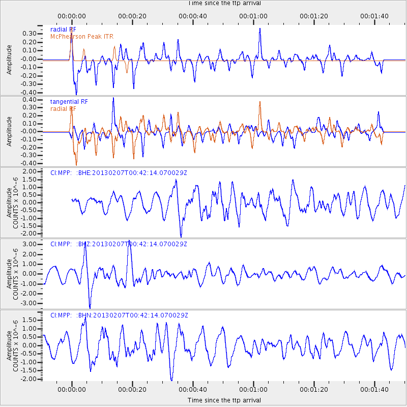
MPP McPhearson Peak - Earthquake Result Viewer
*The percent match for this event was below the threshold and hence no stack was calculated.
| Earthquake location: |
Santa Cruz Islands Region |
| Earthquake latitude/longitude: |
-11.7/164.9 |
| Earthquake time(UTC): |
2013/02/07 (038) 00:30:10 GMT |
| Earthquake Depth: |
8.0 km |
| Earthquake Magnitude: |
6.0 MB, 5.9 MS, 6.0 MW, 6.0 MW |
| Earthquake Catalog/Contributor: |
WHDF/NEIC |
|
| Network: |
CI Caltech Regional Seismic Network |
| Station: |
MPP McPhearson Peak |
| Lat/Lon: |
34.89 N/119.81 W |
| Elevation: |
1739 m |
|
| Distance: |
84.8 deg |
| Az: |
52.964 deg |
| Baz: |
252.039 deg |
| Ray Param: |
$rayparam |
*The percent match for this event was below the threshold and hence was not used in the summary stack. |
|
| Radial Match: |
73.82026 % |
| Radial Bump: |
400 |
| Transverse Match: |
73.3013 % |
| Transverse Bump: |
400 |
| SOD ConfigId: |
494114 |
| Insert Time: |
2013-05-01 08:17:48.837 +0000 |
| GWidth: |
2.5 |
| Max Bumps: |
400 |
| Tol: |
0.001 |
|
Signal To Noise
| Channel | StoN | STA | LTA |
| CI:MPP: :BHZ:20130207T00:42:14.070029Z | 1.9370618 | 1.1864147E-6 | 6.1248164E-7 |
| CI:MPP: :BHN:20130207T00:42:14.070029Z | 1.9944434 | 9.3201226E-7 | 4.6730443E-7 |
| CI:MPP: :BHE:20130207T00:42:14.070029Z | 1.7939885 | 8.0042753E-7 | 4.4617207E-7 |
| Arrivals |
| Ps | |
| PpPs | |
| PsPs/PpSs | |


