You are here: Home > Network List > XD14 - Illuminating the architecture of the greater Mount St. Helens magmatic systems f Stations List
> Station MI04 "Mount St Helens, WA" > Earthquake Result Viewer
MI04 "Mount St Helens, WA" - Earthquake Result Viewer
| Earthquake location: |
South Of Kermadec Islands |
| Earthquake latitude/longitude: |
-33.7/-179.3 |
| Earthquake time(UTC): |
2014/06/29 (180) 23:42:05 GMT |
| Earthquake Depth: |
55 km |
| Earthquake Magnitude: |
4.8 mb |
| Earthquake Catalog/Contributor: |
ISC/ISC |
|
| Network: |
XD Illuminating the architecture of the greater Mount St. Helens magmatic systems f |
| Station: |
MI04 "Mount St Helens, WA" |
| Lat/Lon: |
46.20 N/122.41 W |
| Elevation: |
918 m |
|
| Distance: |
94.7 deg |
| Az: |
35.715 deg |
| Baz: |
224.448 deg |
| Ray Param: |
0.040950965 |
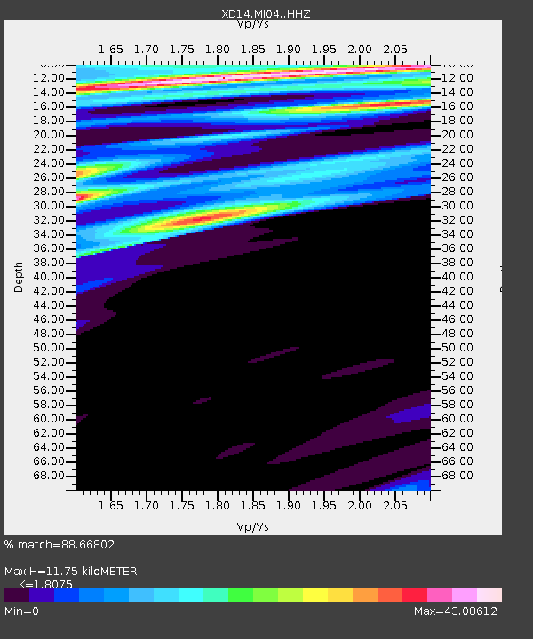
| Estimated Moho Depth: |
11.75 km |
| Estimated Crust Vp/Vs: |
1.81 |
| Assumed Crust Vp: |
6.566 km/s |
| Estimated Crust Vs: |
3.633 km/s |
| Estimated Crust Poisson's Ratio: |
0.28 |
|
| Radial Match: |
88.66802 % |
| Radial Bump: |
258 |
| Transverse Match: |
89.87284 % |
| Transverse Bump: |
246 |
| SOD ConfigId: |
3390531 |
| Insert Time: |
2019-04-12 15:03:55.938 +0000 |
| GWidth: |
2.5 |
| Max Bumps: |
400 |
| Tol: |
0.001 |
|

Signal To Noise
| Channel | StoN | STA | LTA |
| XD:MI04: :HHZ:20140629T23:54:49.175002Z | 1.1606954 | 3.7133222E-7 | 3.1992218E-7 |
| XD:MI04: :HHN:20140629T23:54:49.175002Z | 2.3119788 | 1.96009E-5 | 8.477976E-6 |
| XD:MI04: :HHE:20140629T23:54:49.175002Z | 3.2449992 | 1.3382961E-5 | 4.12418E-6 |
| Arrivals |
| Ps | 1.5 SECOND |
| PpPs | 4.9 SECOND |
| PsPs/PpSs | 6.4 SECOND |


