You are here: Home > Network List > GT - Global Telemetered Seismograph Network (USAF/USGS) Stations List
> Station BOSA Boshof, South Africa > Earthquake Result Viewer
BOSA Boshof, South Africa - Earthquake Result Viewer
| Earthquake location: |
South Atlantic Ocean |
| Earthquake latitude/longitude: |
-53.6/-51.5 |
| Earthquake time(UTC): |
1993/09/27 (270) 13:37:32 GMT |
| Earthquake Depth: |
33 km |
| Earthquake Magnitude: |
6.1 MB, 6.4 MS, 6.3 UNKNOWN, 6.7 MW |
| Earthquake Catalog/Contributor: |
WHDF/NEIC |
|
| Network: |
GT Global Telemetered Seismograph Network (USAF/USGS) |
| Station: |
BOSA Boshof, South Africa |
| Lat/Lon: |
28.61 S/25.26 E |
| Elevation: |
1280 m |
|
| Distance: |
59.8 deg |
| Az: |
98.112 deg |
| Baz: |
222.092 deg |
| Ray Param: |
0.06187451 |
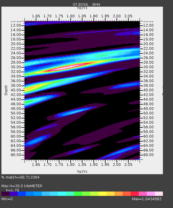
| Estimated Moho Depth: |
30.0 km |
| Estimated Crust Vp/Vs: |
1.78 |
| Assumed Crust Vp: |
6.459 km/s |
| Estimated Crust Vs: |
3.629 km/s |
| Estimated Crust Poisson's Ratio: |
0.27 |
|
| Radial Match: |
88.713394 % |
| Radial Bump: |
304 |
| Transverse Match: |
65.69766 % |
| Transverse Bump: |
400 |
| SOD ConfigId: |
16938 |
| Insert Time: |
2010-02-27 01:43:33.459 +0000 |
| GWidth: |
2.5 |
| Max Bumps: |
400 |
| Tol: |
0.001 |
|
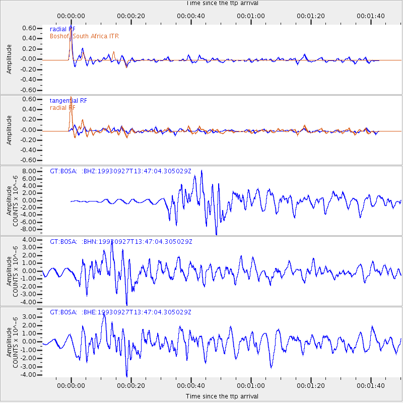
Signal To Noise
| Channel | StoN | STA | LTA |
| GT:BOSA: :BHN:19930927T13:47:04.305029Z | 2.6783412 | 8.5411983E-7 | 3.188988E-7 |
| GT:BOSA: :BHE:19930927T13:47:04.305029Z | 4.634075 | 1.2497579E-6 | 2.6968877E-7 |
| GT:BOSA: :BHZ:19930927T13:47:04.305029Z | 5.5186567 | 1.8099878E-6 | 3.2797615E-7 |
| Arrivals |
| Ps | 3.8 SECOND |
| PpPs | 12 SECOND |
| PsPs/PpSs | 16 SECOND |


