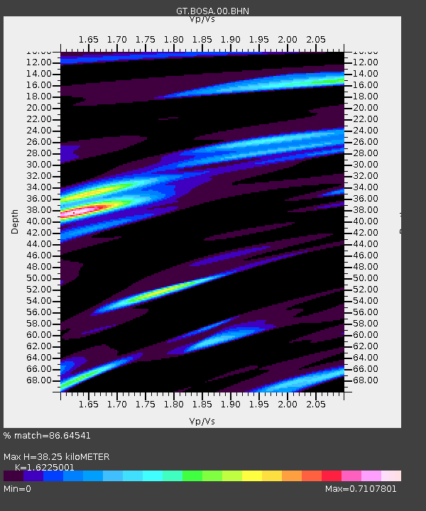
BOSA Boshof, South Africa - Earthquake Result Viewer
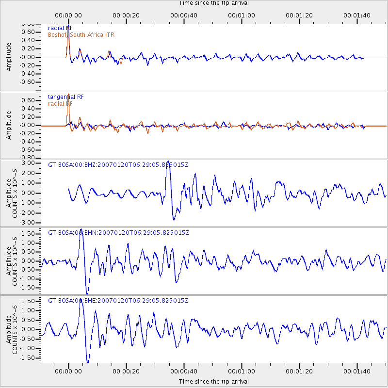
Earthquake location: South Sandwich Islands Region
Earthquake latitude/longitude: -55.4/-29.5
Earthquake time(UTC): 2007/01/20 (020) 06:21:04 GMT
Earthquake Depth: 10 km
Earthquake Magnitude: 5.7 MB, 6.2 MS, 6.2 MW, 6.1 MW
Earthquake Catalog/Contributor: WHDF/NEIC
Network: GT Global Telemetered Seismograph Network (USAF/USGS)
Station: BOSA Boshof, South Africa
Lat/Lon: 28.61 S/25.26 E
Elevation: 1280 m
Distance: 47.1 deg
Az: 78.6 deg
Baz: 219.471 deg
Ray Param: 0.07020067
Estimated Moho Depth: 38.25 km
Estimated Crust Vp/Vs: 1.62
Assumed Crust Vp: 6.459 km/s
Estimated Crust Vs: 3.981 km/s
Estimated Crust Poisson's Ratio: 0.19
Radial Match: 86.64541 %
Radial Bump: 400
Transverse Match: 55.007545 %
Transverse Bump: 400
SOD ConfigId: 2564
Insert Time: 2010-02-27 01:43:59.546 +0000
GWidth: 2.5
Max Bumps: 400
Tol: 0.001

Signal To Noise

ChannelStoNSTALTA
GT:BOSA:00:BHN:20070120T06:29:05.825015Z2.44616347.6128975E-73.1121786E-7
GT:BOSA:00:BHE:20070120T06:29:05.825015Z3.11824587.015139E-72.2497069E-7
GT:BOSA:00:BHZ:20070120T06:29:05.825015Z3.74777221.3867392E-63.7001695E-7
Arrivals
Ps3.9 SECOND
PpPs15 SECOND
PsPs/PpSs18 SECOND