You are here: Home > Network List > AU - Australian Seismological Centre Stations List
> Station KNRA Kunnunarra, Western Australia > Earthquake Result Viewer
KNRA Kunnunarra, Western Australia - Earthquake Result Viewer
| Earthquake location: |
Santa Cruz Islands |
| Earthquake latitude/longitude: |
-10.8/166.0 |
| Earthquake time(UTC): |
2013/02/08 (039) 11:12:11 GMT |
| Earthquake Depth: |
12 km |
| Earthquake Magnitude: |
6.3 MB, 6.9 MS, 6.8 MW, 6.8 MW |
| Earthquake Catalog/Contributor: |
WHDF/NEIC |
|
| Network: |
AU Australian Seismological Centre |
| Station: |
KNRA Kunnunarra, Western Australia |
| Lat/Lon: |
15.68 S/128.76 E |
| Elevation: |
101 m |
|
| Distance: |
36.5 deg |
| Az: |
258.314 deg |
| Baz: |
87.094 deg |
| Ray Param: |
0.07664263 |
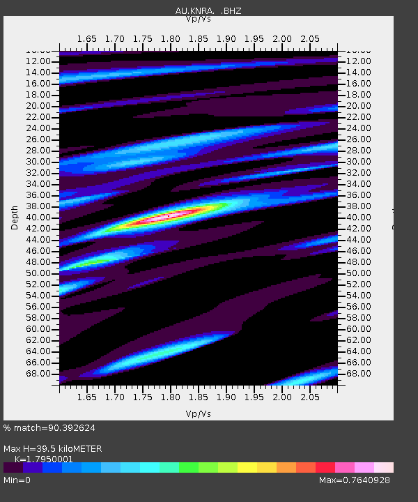
| Estimated Moho Depth: |
39.5 km |
| Estimated Crust Vp/Vs: |
1.80 |
| Assumed Crust Vp: |
6.397 km/s |
| Estimated Crust Vs: |
3.564 km/s |
| Estimated Crust Poisson's Ratio: |
0.27 |
|
| Radial Match: |
90.392624 % |
| Radial Bump: |
300 |
| Transverse Match: |
82.10143 % |
| Transverse Bump: |
400 |
| SOD ConfigId: |
494114 |
| Insert Time: |
2013-05-01 08:49:09.369 +0000 |
| GWidth: |
2.5 |
| Max Bumps: |
400 |
| Tol: |
0.001 |
|

Signal To Noise
| Channel | StoN | STA | LTA |
| AU:KNRA: :BHZ:20130208T11:18:45.719991Z | 1.925595 | 6.431888E-7 | 3.340208E-7 |
| AU:KNRA: :BHN:20130208T11:18:45.719991Z | 0.6628022 | 1.3314775E-7 | 2.0088608E-7 |
| AU:KNRA: :BHE:20130208T11:18:45.719991Z | 0.95136017 | 2.6248773E-7 | 2.7590784E-7 |
| Arrivals |
| Ps | 5.3 SECOND |
| PpPs | 16 SECOND |
| PsPs/PpSs | 21 SECOND |


