You are here: Home > Network List > AK - Alaska Regional Network Stations List
> Station HDA Harding Lake, AK, USA > Earthquake Result Viewer
HDA Harding Lake, AK, USA - Earthquake Result Viewer
| Earthquake location: |
Santa Cruz Islands |
| Earthquake latitude/longitude: |
-10.9/166.0 |
| Earthquake time(UTC): |
2013/02/08 (039) 15:26:38 GMT |
| Earthquake Depth: |
21 km |
| Earthquake Magnitude: |
6.4 MB, 6.9 MS, 7.1 MW, 7.1 MW |
| Earthquake Catalog/Contributor: |
WHDF/NEIC |
|
| Network: |
AK Alaska Regional Network |
| Station: |
HDA Harding Lake, AK, USA |
| Lat/Lon: |
64.41 N/146.95 W |
| Elevation: |
437 m |
|
| Distance: |
83.0 deg |
| Az: |
18.673 deg |
| Baz: |
226.385 deg |
| Ray Param: |
0.046444245 |
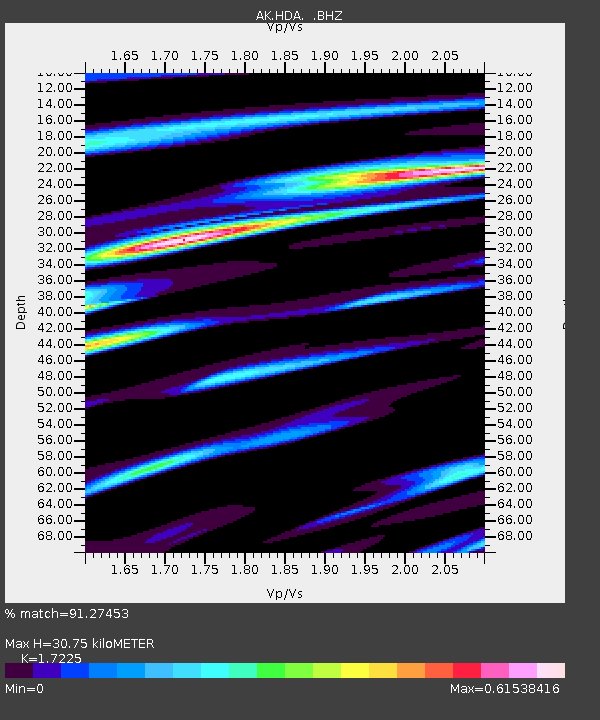
| Estimated Moho Depth: |
30.75 km |
| Estimated Crust Vp/Vs: |
1.72 |
| Assumed Crust Vp: |
6.566 km/s |
| Estimated Crust Vs: |
3.812 km/s |
| Estimated Crust Poisson's Ratio: |
0.25 |
|
| Radial Match: |
91.27453 % |
| Radial Bump: |
400 |
| Transverse Match: |
82.47162 % |
| Transverse Bump: |
400 |
| SOD ConfigId: |
494114 |
| Insert Time: |
2013-05-01 08:54:45.049 +0000 |
| GWidth: |
2.5 |
| Max Bumps: |
400 |
| Tol: |
0.001 |
|

Signal To Noise
| Channel | StoN | STA | LTA |
| AK:HDA: :BHZ:20130208T15:38:30.88803Z | 1.7097919 | 4.941704E-7 | 2.8902372E-7 |
| AK:HDA: :BHN:20130208T15:38:30.88803Z | 1.1382797 | 2.610812E-7 | 2.293647E-7 |
| AK:HDA: :BHE:20130208T15:38:30.88803Z | 1.3437884 | 2.7593197E-7 | 2.0533885E-7 |
| Arrivals |
| Ps | 3.5 SECOND |
| PpPs | 12 SECOND |
| PsPs/PpSs | 16 SECOND |


