You are here: Home > Network List > TA - USArray Transportable Network (new EarthScope stations) Stations List
> Station TPFO Pinon Flats, CA, USA > Earthquake Result Viewer
TPFO Pinon Flats, CA, USA - Earthquake Result Viewer
| Earthquake location: |
Solomon Islands |
| Earthquake latitude/longitude: |
-6.3/154.7 |
| Earthquake time(UTC): |
2013/02/08 (039) 17:59:53 GMT |
| Earthquake Depth: |
93 km |
| Earthquake Magnitude: |
5.7 MB |
| Earthquake Catalog/Contributor: |
WHDF/NEIC |
|
| Network: |
TA USArray Transportable Network (new EarthScope stations) |
| Station: |
TPFO Pinon Flats, CA, USA |
| Lat/Lon: |
33.61 N/116.45 W |
| Elevation: |
1275 m |
|
| Distance: |
92.5 deg |
| Az: |
56.633 deg |
| Baz: |
264.107 deg |
| Ray Param: |
0.041404683 |
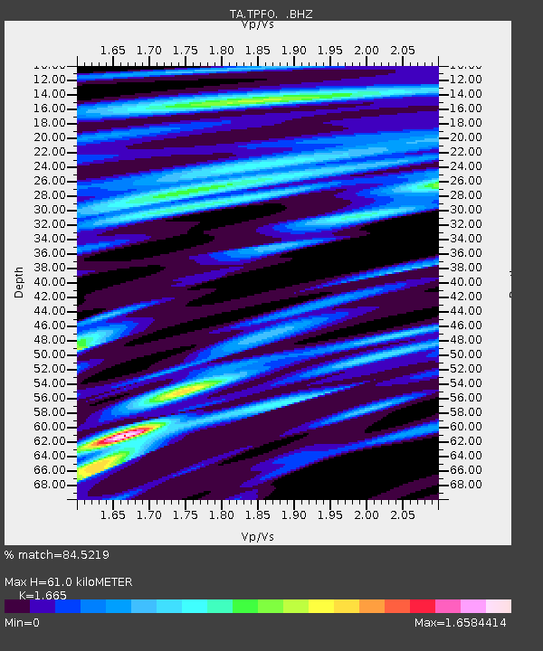
| Estimated Moho Depth: |
61.0 km |
| Estimated Crust Vp/Vs: |
1.66 |
| Assumed Crust Vp: |
6.264 km/s |
| Estimated Crust Vs: |
3.762 km/s |
| Estimated Crust Poisson's Ratio: |
0.22 |
|
| Radial Match: |
84.5219 % |
| Radial Bump: |
325 |
| Transverse Match: |
80.74737 % |
| Transverse Bump: |
400 |
| SOD ConfigId: |
494114 |
| Insert Time: |
2013-05-01 09:02:41.478 +0000 |
| GWidth: |
2.5 |
| Max Bumps: |
400 |
| Tol: |
0.001 |
|
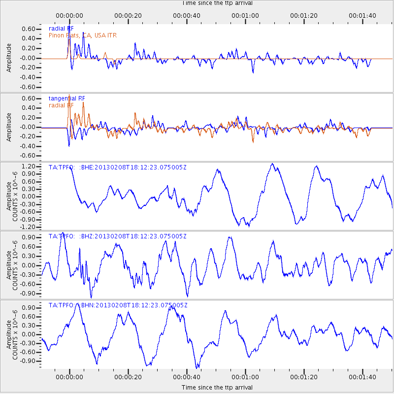
Signal To Noise
| Channel | StoN | STA | LTA |
| TA:TPFO: :BHZ:20130208T18:12:23.075005Z | 0.72122747 | 2.485592E-7 | 3.4463355E-7 |
| TA:TPFO: :BHN:20130208T18:12:23.075005Z | 4.1174316 | 7.9092354E-7 | 1.9209148E-7 |
| TA:TPFO: :BHE:20130208T18:12:23.075005Z | 0.53637683 | 2.0123184E-7 | 3.751688E-7 |
| Arrivals |
| Ps | 6.6 SECOND |
| PpPs | 25 SECOND |
| PsPs/PpSs | 32 SECOND |


