You are here: Home > Network List > UW - Pacific Northwest Regional Seismic Network Stations List
> Station HOOD Mt Hood Meadows, OR CREST BB SMO > Earthquake Result Viewer
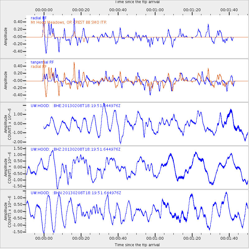
HOOD Mt Hood Meadows, OR CREST BB SMO - Earthquake Result Viewer
*The percent match for this event was below the threshold and hence no stack was calculated.
| Earthquake location: |
Santa Cruz Islands |
| Earthquake latitude/longitude: |
-10.9/166.6 |
| Earthquake time(UTC): |
2013/02/08 (039) 18:07:46 GMT |
| Earthquake Depth: |
10 km |
| Earthquake Magnitude: |
5.6 MB, 5.5 MS, 5.7 MW |
| Earthquake Catalog/Contributor: |
WHDF/NEIC |
|
| Network: |
UW Pacific Northwest Regional Seismic Network |
| Station: |
HOOD Mt Hood Meadows, OR CREST BB SMO |
| Lat/Lon: |
45.32 N/121.65 W |
| Elevation: |
1520 m |
|
| Distance: |
85.1 deg |
| Az: |
42.245 deg |
| Baz: |
249.4 deg |
| Ray Param: |
$rayparam |
*The percent match for this event was below the threshold and hence was not used in the summary stack. |
|
| Radial Match: |
72.17123 % |
| Radial Bump: |
400 |
| Transverse Match: |
76.11338 % |
| Transverse Bump: |
400 |
| SOD ConfigId: |
494114 |
| Insert Time: |
2013-05-01 09:07:08.838 +0000 |
| GWidth: |
2.5 |
| Max Bumps: |
400 |
| Tol: |
0.001 |
|
Signal To Noise
| Channel | StoN | STA | LTA |
| UW:HOOD: :BHZ:20130208T18:19:51.644976Z | 1.8110116 | 7.2295984E-7 | 3.9920224E-7 |
| UW:HOOD: :BHN:20130208T18:19:51.644976Z | 2.080428 | 1.0167527E-6 | 4.887229E-7 |
| UW:HOOD: :BHE:20130208T18:19:51.644976Z | 2.7141545 | 1.4008742E-6 | 5.161365E-7 |
| Arrivals |
| Ps | |
| PpPs | |
| PsPs/PpSs | |


