You are here: Home > Network List > TA - USArray Transportable Network (new EarthScope stations) Stations List
> Station N23A Red Feather Lakes, CO, USA > Earthquake Result Viewer
N23A Red Feather Lakes, CO, USA - Earthquake Result Viewer

| Earthquake location: |
Santa Cruz Islands |
| Earthquake latitude/longitude: |
-10.9/166.0 |
| Earthquake time(UTC): |
2013/02/09 (040) 05:32:07 GMT |
| Earthquake Depth: |
9.0 km |
| Earthquake Magnitude: |
5.5 MB, 5.2 MS, 5.5 MW, 5.6 MW |
| Earthquake Catalog/Contributor: |
WHDF/NEIC |
|
| Network: |
TA USArray Transportable Network (new EarthScope stations) |
| Station: |
N23A Red Feather Lakes, CO, USA |
| Lat/Lon: |
40.89 N/105.94 W |
| Elevation: |
2458 m |
|
| Distance: |
95.6 deg |
| Az: |
49.578 deg |
| Baz: |
260.539 deg |
| Ray Param: |
0.040740404 |
| Estimated Moho Depth: |
18.5 km |
| Estimated Crust Vp/Vs: |
1.61 |
| Assumed Crust Vp: |
6.306 km/s |
| Estimated Crust Vs: |
3.929 km/s |
| Estimated Crust Poisson's Ratio: |
0.18 |
|
| Radial Match: |
87.98752 % |
| Radial Bump: |
400 |
| Transverse Match: |
75.13174 % |
| Transverse Bump: |
400 |
| SOD ConfigId: |
494114 |
| Insert Time: |
2013-05-01 09:13:21.968 +0000 |
| GWidth: |
2.5 |
| Max Bumps: |
400 |
| Tol: |
0.001 |
|
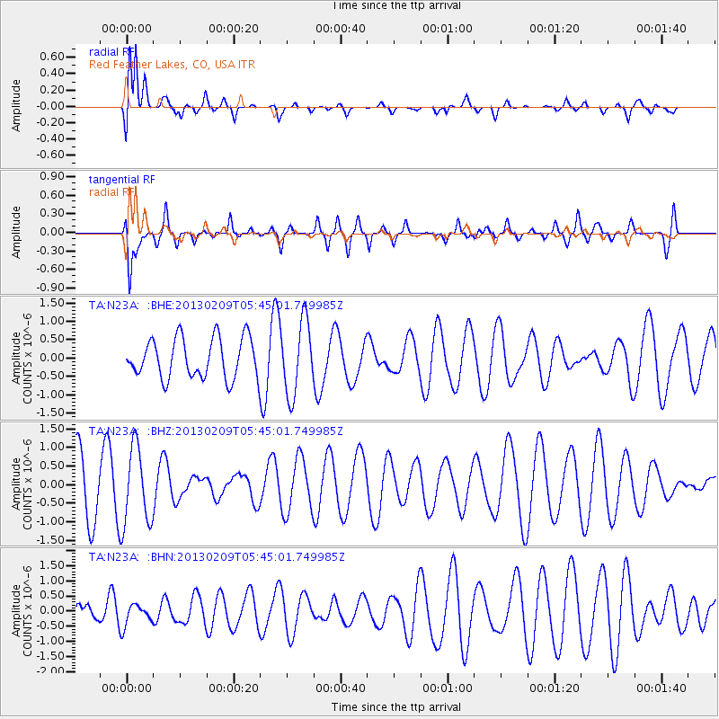
Signal To Noise
| Channel | StoN | STA | LTA |
| TA:N23A: :BHZ:20130209T05:45:01.749985Z | 1.3840915 | 1.0256038E-6 | 7.409942E-7 |
| TA:N23A: :BHN:20130209T05:45:01.749985Z | 0.5954272 | 3.4660488E-7 | 5.821112E-7 |
| TA:N23A: :BHE:20130209T05:45:01.749985Z | 1.8323358 | 9.96751E-7 | 5.439784E-7 |
| Arrivals |
| Ps | 1.8 SECOND |
| PpPs | 7.5 SECOND |
| PsPs/PpSs | 9.3 SECOND |


