You are here: Home > Network List > TA - USArray Transportable Network (new EarthScope stations) Stations List
> Station POKR Poker Plat Research Range, AK, USA > Earthquake Result Viewer
POKR Poker Plat Research Range, AK, USA - Earthquake Result Viewer
| Earthquake location: |
Santa Cruz Islands |
| Earthquake latitude/longitude: |
-10.9/166.0 |
| Earthquake time(UTC): |
2013/02/09 (040) 05:32:07 GMT |
| Earthquake Depth: |
9.0 km |
| Earthquake Magnitude: |
5.5 MB, 5.2 MS, 5.5 MW, 5.6 MW |
| Earthquake Catalog/Contributor: |
WHDF/NEIC |
|
| Network: |
TA USArray Transportable Network (new EarthScope stations) |
| Station: |
POKR Poker Plat Research Range, AK, USA |
| Lat/Lon: |
65.12 N/147.43 W |
| Elevation: |
501 m |
|
| Distance: |
83.4 deg |
| Az: |
18.028 deg |
| Baz: |
225.93 deg |
| Ray Param: |
0.04624136 |
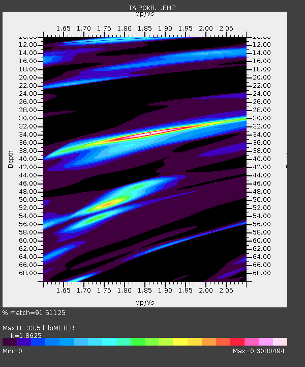
| Estimated Moho Depth: |
33.5 km |
| Estimated Crust Vp/Vs: |
1.86 |
| Assumed Crust Vp: |
6.566 km/s |
| Estimated Crust Vs: |
3.525 km/s |
| Estimated Crust Poisson's Ratio: |
0.30 |
|
| Radial Match: |
91.51125 % |
| Radial Bump: |
274 |
| Transverse Match: |
55.303486 % |
| Transverse Bump: |
305 |
| SOD ConfigId: |
494114 |
| Insert Time: |
2013-05-01 09:13:38.539 +0000 |
| GWidth: |
2.5 |
| Max Bumps: |
400 |
| Tol: |
0.001 |
|

Signal To Noise
| Channel | StoN | STA | LTA |
| TA:POKR: :BHZ:20130209T05:44:03.77501Z | 1.6299491 | 3.4716635E-7 | 2.1299215E-7 |
| TA:POKR: :BHN:20130209T05:44:03.77501Z | 1.8349075 | 3.8045607E-7 | 2.0734345E-7 |
| TA:POKR: :BHE:20130209T05:44:03.77501Z | 1.8787488 | 3.8224204E-7 | 2.0345563E-7 |
| Arrivals |
| Ps | 4.5 SECOND |
| PpPs | 14 SECOND |
| PsPs/PpSs | 19 SECOND |


