You are here: Home > Network List > AZ - ANZA Regional Network Stations List
> Station SMER AZ.SMER > Earthquake Result Viewer
SMER AZ.SMER - Earthquake Result Viewer
| Earthquake location: |
Colombia |
| Earthquake latitude/longitude: |
1.1/-77.4 |
| Earthquake time(UTC): |
2013/02/09 (040) 14:16:07 GMT |
| Earthquake Depth: |
145 km |
| Earthquake Magnitude: |
6.7 MB, 6.9 MW, 6.9 MW |
| Earthquake Catalog/Contributor: |
WHDF/NEIC |
|
| Network: |
AZ ANZA Regional Network |
| Station: |
SMER AZ.SMER |
| Lat/Lon: |
33.46 N/117.17 W |
| Elevation: |
355 m |
|
| Distance: |
49.2 deg |
| Az: |
315.06 deg |
| Baz: |
122.351 deg |
| Ray Param: |
0.0683419 |
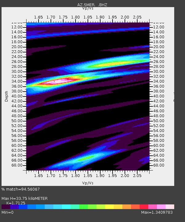
| Estimated Moho Depth: |
33.75 km |
| Estimated Crust Vp/Vs: |
1.71 |
| Assumed Crust Vp: |
6.264 km/s |
| Estimated Crust Vs: |
3.658 km/s |
| Estimated Crust Poisson's Ratio: |
0.24 |
|
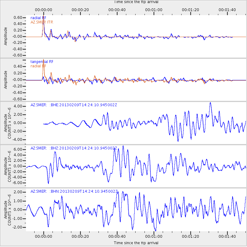
| Radial Match: |
94.56067 % |
| Radial Bump: |
368 |
| Transverse Match: |
74.38143 % |
| Transverse Bump: |
400 |
| SOD ConfigId: |
494114 |
| Insert Time: |
2013-05-01 09:18:27.051 +0000 |
| GWidth: |
2.5 |
| Max Bumps: |
400 |
| Tol: |
0.001 |
|
Signal To Noise
| Channel | StoN | STA | LTA |
| AZ:SMER: :BHZ:20130209T14:24:10.945002Z | 7.186978 | 2.3118187E-6 | 3.2166773E-7 |
| AZ:SMER: :BHN:20130209T14:24:10.945002Z | 2.9094434 | 7.3437974E-7 | 2.5241246E-7 |
| AZ:SMER: :BHE:20130209T14:24:10.945002Z | 3.356604 | 1.0813765E-6 | 3.2216383E-7 |
| Arrivals |
| Ps | 4.1 SECOND |
| PpPs | 14 SECOND |
| PsPs/PpSs | 18 SECOND |


