You are here: Home > Network List > GT - Global Telemetered Seismograph Network (USAF/USGS) Stations List
> Station BOSA Boshof, South Africa > Earthquake Result Viewer
BOSA Boshof, South Africa - Earthquake Result Viewer
| Earthquake location: |
Southeast Indian Ridge |
| Earthquake latitude/longitude: |
-53.0/106.8 |
| Earthquake time(UTC): |
2008/12/08 (343) 18:39:09 GMT |
| Earthquake Depth: |
10 km |
| Earthquake Magnitude: |
6.2 MB, 5.9 MS, 6.3 MW, 6.3 MW |
| Earthquake Catalog/Contributor: |
WHDF/NEIC |
|
| Network: |
GT Global Telemetered Seismograph Network (USAF/USGS) |
| Station: |
BOSA Boshof, South Africa |
| Lat/Lon: |
28.61 S/25.26 E |
| Elevation: |
1280 m |
|
| Distance: |
62.8 deg |
| Az: |
257.978 deg |
| Baz: |
137.756 deg |
| Ray Param: |
0.060006723 |
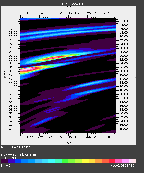
| Estimated Moho Depth: |
36.75 km |
| Estimated Crust Vp/Vs: |
1.63 |
| Assumed Crust Vp: |
6.459 km/s |
| Estimated Crust Vs: |
3.963 km/s |
| Estimated Crust Poisson's Ratio: |
0.20 |
|
| Radial Match: |
93.37311 % |
| Radial Bump: |
289 |
| Transverse Match: |
76.257545 % |
| Transverse Bump: |
400 |
| SOD ConfigId: |
2658 |
| Insert Time: |
2010-02-27 01:44:40.225 +0000 |
| GWidth: |
2.5 |
| Max Bumps: |
400 |
| Tol: |
0.001 |
|
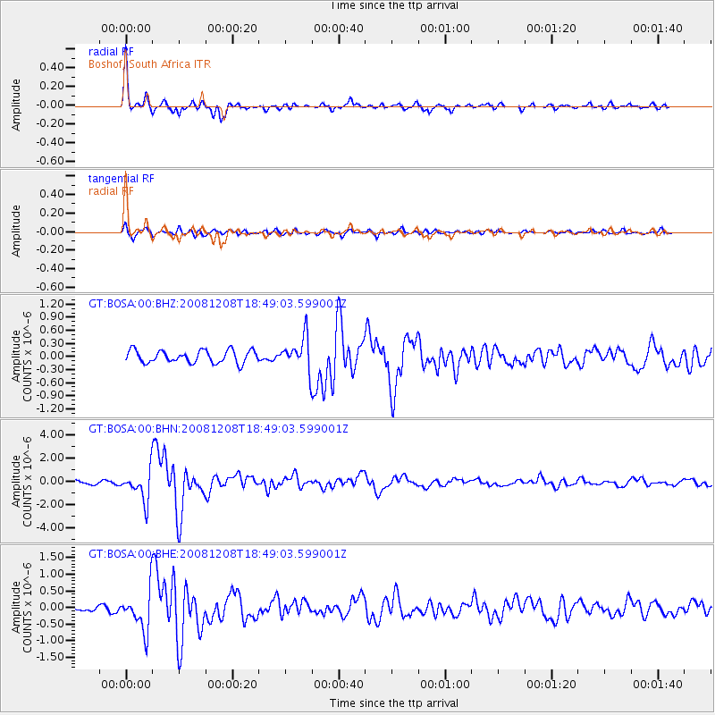
Signal To Noise
| Channel | StoN | STA | LTA |
| GT:BOSA:00:BHN:20081208T18:49:03.599001Z | 8.505328 | 1.3163718E-6 | 1.5477025E-7 |
| GT:BOSA:00:BHE:20081208T18:49:03.599001Z | 6.323779 | 6.0732236E-7 | 9.603788E-8 |
| GT:BOSA:00:BHZ:20081208T18:49:03.599001Z | 2.6998954 | 3.8454885E-7 | 1.4243103E-7 |
| Arrivals |
| Ps | 3.8 SECOND |
| PpPs | 14 SECOND |
| PsPs/PpSs | 18 SECOND |


