You are here: Home > Network List > CI - Caltech Regional Seismic Network Stations List
> Station LRL Laurel Mtn Radio Fac, Ridgecrest, CA, USA > Earthquake Result Viewer
LRL Laurel Mtn Radio Fac, Ridgecrest, CA, USA - Earthquake Result Viewer

| Earthquake location: |
Colombia |
| Earthquake latitude/longitude: |
1.1/-77.4 |
| Earthquake time(UTC): |
2013/02/09 (040) 14:16:07 GMT |
| Earthquake Depth: |
145 km |
| Earthquake Magnitude: |
6.7 MB, 6.9 MW, 6.9 MW |
| Earthquake Catalog/Contributor: |
WHDF/NEIC |
|
| Network: |
CI Caltech Regional Seismic Network |
| Station: |
LRL Laurel Mtn Radio Fac, Ridgecrest, CA, USA |
| Lat/Lon: |
35.48 N/117.68 W |
| Elevation: |
1340 m |
|
| Distance: |
50.7 deg |
| Az: |
316.975 deg |
| Baz: |
123.296 deg |
| Ray Param: |
0.06741627 |
| Estimated Moho Depth: |
23.5 km |
| Estimated Crust Vp/Vs: |
1.93 |
| Assumed Crust Vp: |
6.276 km/s |
| Estimated Crust Vs: |
3.243 km/s |
| Estimated Crust Poisson's Ratio: |
0.32 |
|
| Radial Match: |
91.08692 % |
| Radial Bump: |
400 |
| Transverse Match: |
80.64797 % |
| Transverse Bump: |
400 |
| SOD ConfigId: |
494114 |
| Insert Time: |
2013-05-01 09:21:20.440 +0000 |
| GWidth: |
2.5 |
| Max Bumps: |
400 |
| Tol: |
0.001 |
|
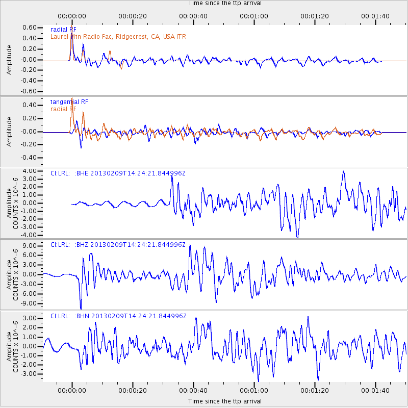
Signal To Noise
| Channel | StoN | STA | LTA |
| CI:LRL: :BHZ:20130209T14:24:21.844996Z | 13.929798 | 3.5770743E-6 | 2.56793E-7 |
| CI:LRL: :BHN:20130209T14:24:21.844996Z | 1.2358326 | 9.098085E-7 | 7.361907E-7 |
| CI:LRL: :BHE:20130209T14:24:21.844996Z | 5.6356373 | 1.2008308E-6 | 2.1307808E-7 |
| Arrivals |
| Ps | 3.7 SECOND |
| PpPs | 10 SECOND |
| PsPs/PpSs | 14 SECOND |


